Robert Norman’s The Newe Attractive (1581) was the most scientific study of magnetism and the magnetic compass between Petrus Peregrinus’ Epistola de magnete from 1269 and William Gilbert’s De Magnete from 1600 and like the former featured strongly in the latter.
As is all too often the case with comparatively minor Renaissance figures we know next to nothing about Robert Norman. His dates of birth and death are unknown and all that is known about his origins is that they were humble. According to his own account he spent eighteen or twenty years at sea before he settled down at Ratliffe (Ratcliff) part of the Manor and Ancient Parish of Stepney on the north bank of the Thames between Limehouse (to the east) and Shadwell (to the west), as an instrument maker and self-styled ‘hydrographer’.
The Hamlet (administrative sub-division) of Ratcliff in Joel Gascoyne’s 1703 map of the Parish of Stepney Source: Wikimedia Commons
Ratcliffe in earlier times was also known as “sailor town”. It was originally known for shipbuilding but from the fourteenth century more for fitting and provisioning ships. In the sixteenth century various voyages of discovery were supplied and departed from Ratcliffe, including those of Willoughby and Frobisher.
Wikipedia
Norman’s principal claim to fame is as the discoverer of the second deviation of the magnetic compass needle, after variation or declination, magnetic dip or inclination. This, as observed by Norman, was the fact that the compass needles that he made did not sit horizontally on the middle point but the north end dip down at the north end, as he described it in chapter three of his The Newe Attractive:
“…rising alwaies to finish and end the, before I touched the needle I found continually that after I touched the Irons … the North point … would bende under the Horizon…”
The modern definition:
Magnetic dip, dip angle, or magnetic inclination is the angle made with the horizontal by the Earth’s magnetic field lines. This angle varies at different points on the Earth’s surface. Positive values of inclination indicate that the magnetic field of the Earth is pointing downward, into the Earth, at the point of measurement, and negative values indicate that it is pointing upward. The dip angle is in principle the angle made by the needle of a vertically held compass. (Wikipedia)
Strictly speaking Norman was not the first to discover magnetic dip, that honour goes to the Franconian astronomer, mathematician and instrument maker, Georg Hartmann (1489–1564), who discovered it in 1544 and described it, with a lot of other information on magnetism and compasses, in a letter he wrote to Duke Albrecht of Prussia (1490–1568). However, he never published his discovery, and the letter to Albrecht only became known in the nineteenth century, so the laurels for the discovery are usually awarded to Norman. On a side note, Hartmann measured the magnetic variation of Rome in 1510 finding it to be 6°.
Georg Hartmann Source: Astronomie in Nürnberg
Norman first noticed the dip on a six-inch compass needle that he had manufactured and initially thought that it had been somehow spoilt during the making process. He devised a series of experiments to try and find the cause and discovered that the needle was OK, and the cause was some attractive power of the Earth. Having discovered that dip was a natural phenomenon and constructed a dip-circle and measured the angle of dip for London that he measured accurately as 71° 51’.
Figure of a dip circle, illustrating magnetic dip Robert Norman – Page 17 of The Newe Attractive via Wikimedia Commons
The discovery of magnetic dip and Norman’s invention of the dip-circle to measure it led to speculation that dip could be used to determine latitude by overcast skies in the same way that it had been hoped to determine longitude by magnetic variation. Although, the dip-circle became a standard piece of the navigator’s equipment throughout the seventeenth century its use to determine latitude never came about.
Having dealt with the phenomenon of magnetic dip in a scientific manner, Robert Norman also turned his attention to magnetic variation. He dismissed the widespread idea that variation was by proportion around the globe and could thus be used to determine longitude citing the observed vagaries of variation. His comments were based on twenty years of experience at sea and the fact that the only people who gave him reliable figures for variation were those engaged in the Muscovy trade, and these did not in any way support the thesis. His book appears to have been the first publication to have an illustration of a compass card with a true north south meridian and a true east west line and then a compass north south line and a false east west line explain and indicating variation.
One important aspect of Norman’s studies of the magnetic compass is that he changed the perception of what actually took place when a compass needle stopped swinging. In the first post in this series, we briefly touched upon the supposed places to which the needle was drawn or attracted, the North Pole, the Pole star, a magnetic mountain or island etc. Norman saw it differently, to quote William Gilbert in his De Magnete:
Robert Norman, an Englishman, posits a point and place to which magnet looks (but whereto it is) not drawn : toward which magnetised iron, according to him is collimated but does not attract it.
Norman also instructed mariners to ensure that their compasses and marine charts had been made by the same people in the same locations. This was to ensure that they were based on the same value for magnetic variation. A compass combined with a marine chart from two different locations based on different variation values could and did lead to serious navigation problems on the open sea. He included a table of five different sorts of sailing compasses with their corresponding marine charts.
David Waters, The Art of Navigation (Henry C. Taylor, 1958) p. 155
The Newe Attractive contained other material useful to navigators. The 1585 second edition contained a Regiment of the Seas “exactlie calculated unto the minute” valid for thirty years and presented in the same form as Medina and William Bourne, which contained a wealth of useful information.
and as I wrote in the episode on Borough the book contained Borough’s A Discourse on the Variation, which was specifically written to be included as an appendix.
This treated the problem of variation “both Practically and Mathematically,” for the enlightenment of the simple and also the learned sort of mariner. Borough’s text contains a lot of polemic on the necessity of learning mathematics for navigation and also urging mariners to determine and record compass variation on their voyages. For this purpose, Robert Norman designed and constructed a new, improved variation compass to make the task of determining variation easier. Borough also strongly supported Norman’s rejection of the idea that variation was by proportion around the globe.
The combined Norman/Borough book went through new expanded and improved editions in 1585, 1592, 1611, and 1614.
In 1584, Norman published a second book, The Safegard of Sailers, or, Great Rutter, a manual of coastal sailing mostly translated from Dutch sources but with additional content of his own.
This book was dedicated to Charles Howard, Earl of Nottingham and Lord High Admiral of England.
Charles Howard (1536-1624), 1st Earl of Nottingham *oil on canvas *208.5 x 139.5 cm *ca. 1620 *inscribed b.l.: Carolus Baro. Howard de Effingham, Comes Nottingham, summus Angliae Admirallus – Ductor Classium 1588 -. Obijt anno 1624. Aetat. 88 Source: Wikimedia Commons
The main thing that distinguishes Robert Norman from other English writers on navigation, magnetism, and the compass in the sixteenth century is the systematic series of experiment that he designed and carried out first, to determine if magnetic dip was a real natural phenomenon and secondly to conceive and construct the dip circle to measure dip. In his ODNB article on Robert Norman, Jim Bennett[1] wrote:
Norman has attracted considerable interest on account of his self-conscious adoption of an experimental approach and his unusual application of instruments. He was deploying his dip circle at a time when instruments were associated not with natural philosophy but with applications of mathematics to practical arts. He was sensitive that, as an ‘unlearned mechanician’, he would scarcely have been expected to concern himself with an area of practical mathematics relevant to natural philosophy, but he vigorously asserted the worth of investigations by practical men, who had the relevant art ‘at their finger ends’, while their more learned critics were ‘in their studies amongest their bookes’. Norman saw himself and his fellow mechanics as heirs to the vernacular tradition of mathematical publication, exemplified by the works of Robert Recorde and Billingsley’s English translation of Euclid.
[1] Jim Bennett was a truly great historian of scientific instruments and history of science museum curator, first in Cambridge at the Whipple and then in Oxford at the History of Science Museum. Sadly he died last Saturday, 28 October 2023, whilst I was using his article to write this blog post.
It is important to note, for the evolution of scientific thought in Europe throughout the centuries after Aristotle, that when applied to nature he didn’t regard mathematical proofs as valid. He argued that the objects of mathematics were not natural and so could not be applied to nature. He did however allow mathematics in what were termed the mixed sciences, astronomy, statics, and optics. For Aristotle mathematical astronomy merely delivered empirical information on the position of the celestial bodies. Their true nature was, however, delivered by non-mathematical cosmology.
In the next three episodes I will be taking a separate look to the three so-called mixed sciences–astronomy, optics, statics–starting with astronomy, because all three would go on to play a significant role in the development of physics in the Early Modern Period.
We have already seen that Aristotle propagated a homocentric, mathematical, astronomical model of the cosmos that was originally conceived by Eudoxus of Cnidus (c. 390–c. 340 BCE), and then further developed by Callippus (c. 370–c. 300 BCE) and Aristotle himself. However, we don’t have any real astronomical texts from any of the three. In what follows I shall be looking at the work of the practical astronomers Hipparchus (Greek: Ίππαρχος, Hipparkhos) (c. 190–c. 120 BCE) and Ptolemaeus (Greek: Πτολεμαῖος, Ptolemaios, English: Ptolemy), which basically means the work of Ptolemaeus, as most of what we know about Hipparchus is taken from the Geographica of Strabo (63 BCE–c. 24 CE), the Naturalis Historia of Plinius (23–79 CE), and Ptolemaeus’ Mathēmatikē Syntaxis or Almagest as it is more commonly known.
Although Ptolemaeus was one of the most influential scholars in antiquity we know almost nothing about him. He appears to have lived and worked in the city of Alexandria during the second century CE and that is quite literally all we know.
Sixteenth century engraving of Ptolemaeus being guided by the personification of astronomy, Astronomia – Margarita Philosophica by Gregor Reisch, published in 1508. Ptolemaeus is shown wearing a crown, as during the Middle Ages, he was thought falsely to be part of the ruling Ptolemaic dynasty Source: Wikimedia Commons19th-century engraving of Hipparchus Source: Wikimedia Commons
We have exactly the same problem with Hipparchus who was born in Nicaea, which is now in Turkey, and is said to have died in Rhodes. The dates given for his life are guestimates based on the known dates of some of his astronomical observations.
Starting with Ptolemaeus’ Mathēmatikē Syntaxis, what this represents is a fully fledged science in the modern sense but which in its development goes back more than a thousand years. The Mathēmatikē Syntaxis is a vast collection of empirical data, which is then analysed to produce a mathematical model of the observable celestial sphere. It is in this sense no different to the astronomical work of Copernicus or Tycho Brahe and the only thing that separates from the work of John Flamsteed, in the time of Newton, is that much of Flamsteed’s empirical data was acquired with a telescope, an instrument that the earlier astronomer did not have available to them.
A 14th.century Greek manuscript of the Mathēmatikē Syntaxis; it shows a table layout, and the functions of the columns, colours and rows are labelled in this depiction. Source: Wikimedia Commons Manuscript source
The Mathēmatikē Syntaxis was published sometime in the middle of the second century CE. It was translated into Arabic in total five times starting around eight hundred. Islamic astronomers studied, analysed, and criticised it. They added new mathematical methods to improve it, but they did nothing to change its fundamental structure.
Arabic Almagest beginnings of the star catalogue Source
It was translated both from the original Greek and from Arabic into Latin in the twelfth century, again without major change.
In the fifteenth century Peuerbach and Regiomontanus produced their Epitome of the Almagest, for Cardinal Bessarion, an updated, modernised, shortened, mathematically improved version of the Almagest.
Epytoma Ioannis de Monte Regio in Almagestum Ptolomei, Latin, 1496 Full manuscript source
The basic concept and structure, however, remained the same and this, in its printed version from 1496, became the standard advanced astronomy textbook in Europe. Copernicus, who learnt his astronomy from the Epitome of the Almagest, and modelled his De revolutionibus (1543)on it.The Mathēmatikē Syntaxis was and remained the archetype for a general presentation of astronomy.
Ptolemaeus’ model is a geocentric one for the obvious reason that it best fitted the available empirical data. As far as the observer is concerned there is no indication that the earth moves in anyway whatsoever, it’s a stable non-moving platform, as far as the observer can tell. This is what makes the mental leap to a heliocentric model so extraordinary. However, even within a heliocentric paradigm astronomical observation remain by definition geocentric until the late twentieth century when the human race made its first tentative steps into space.
Why am I saying this? There is a widespread misconception that somehow Copernicus created a completely new astronomy when he published his De revolutionibus, in reality he didn’t, he ‘merely,’ where merely is doing a lot of work, hypothesised a new model within the astronomical frame that Ptolemaeus had given him in his Mathēmatikē Syntaxis. Tycho Brahe did nothing other with his geo-heliocentric model. The observational astronomy remains the same the mathematical interpretation of the acquired data changes.
Regiomontanus, Wilhelm IV of Hesse-Kassel, and Tycho Brahe all recognised that the data set delivered up in the Mathēmatikē Syntaxis had become corrupted by constant copying of manuscripts and all set about creating new data but using the same basic techniques and instruments as Ptolemaeus. Regiomontanus died before his programme really got of the ground but both Wilhelm and Tycho created new accurate data sets. Tycho developed another new interpretation of the data with his geo-heliocentric model.
A simplified, short explanation of the emergence of modern science during the Early Modern Period is that the qualitative natural philosophy of Aristotle was replaced by a quantitative natural philosophy in which empirical data was analysed and interpreted mathematically. The oft quoted mathematisation of science of which Newton’s Principia Mathematica is held up as the prime example. Ptolemaeus’ Mathēmatikē Syntaxis already offered up a role model for this way of doing science. However, because Aristotle had claimed that mathematics does not or cannot describe reality the Mathēmatikē Syntaxis was generally interpreted, but not as we will see by Ptolemaeus, as being merely a calculating device to determine the position of the celestial object for astrology, cartography, navigation, etc. This, of course, changed with Copernicus, as astronomers began to regard their mathematical models as describing reality. Astronomy became one of the principle driving forces behind the seventeenth-century mathematisation of science.
I’m not going to give a detailed analysis of everything that is in the thirteen books of the Mathēmatikē Syntaxis. I would need a whole blog series for that. However, I will make some salient points of what Ptolemaeus delivers in his complete package.
In the first book he describes a basically Aristotelian image of the cosmos. The Earth a sphere at the centre of a spherical cosmos. Without mentioning either Aristarchus of Samos, who is credited by a couple of sources with having proposed a heliocentric cosmos, or Heraclides Ponticus (c. 390–c. 310 BCE), who proposed a geocentric system with diurnal rotation, Ptolemaeus criticises those who would attribute diurnal rotation to the Earth, anticipating a common criticism of Copernicus. He argues quite logically that if the Earth was rotating on its axis the resulting headwind would cause havoc. Copernicus opposed this argument correctly by claiming that the Earth carries its atmosphere with it in a sort of envelope but couldn’t explain how this physically functioned. Much of the history of physics of the seventeenth century are the incremental steps towards supplying the solution to this problem, culminating in Newton’s theory of universal gravitation.
Ptolemaeus deviates strongly from Aristotelian philosophy in two important aspects. Firstly, it is fairly obvious that he regards his mathematical models as describing reality and not just being a method of calculating the positions of celestial objects. This is something that tended to be ignored by the medieval Aristotelian philosophers, who used the Mathēmatikē Syntaxis. Secondly, because it was not capable of explain all of the properties of the planetary orbits, he abandoned the homocentric spheres model replacing it with variations on an deferent /epicycle model, combined with an eccentric, i.e., the deferent is not centred on the Earth but a point some distance away from it, and with the uniform circular motion measured from an equant point, an abstract point equidistant from the eccentric point as the Earth.
Ptolemaeus’ model of the planetary orbits
This complex geometrical construction led several times down the century to a rejection of the Ptolemaic astronomy and the demand for a return to the Aristotelian homocentric astronomer. The last attempt being by Girolamo Fracastoro (c. 1477–1553) and Giovanni Battista Amico (1511? – 1536), Fracastoro’s book Homocentricorum sive de stellis (Homocentric [Spheres] or Concerning the Stars) being published in 1538, just five years before De revolutionibus.
Portrait of Girolamo Fracastoro by Titian, c.1528 Source: Wikimedia Commons
Ptolemaeus was by no means the originator of all that is contained in his Mathēmatikē Syntaxis, which is a presentation of accumulated astronomical knowledge produced over a couple of thousand years. The most extreme view held by some historians is that he stole or plagiarised all of it from Hipparchus. Others are less drastic in their judgement. However, there is no doubt that he owed a major debt to Hipparchus, which he partially acknowledges.
The story, however, does not begin with Hipparchus. European astronomy has its principal roots in the astronomy of the Babylonians, who began systematic observations of the celestial sphere because of their astrological belief that the heavens controlled/affected life on Earth. Over the centuries they accumulated a vast amount of astronomical data out of which they developed accurate models to predict the movements of the celestial bodies. Unlike the Greeks, these were not geometrical models but numerical algorithms. They also developed an accurate algorithm to predict lunar eclipses. They also had an algorithm to predict when a solar eclipse might take place but could not predict whether it would or not.
Around five hundred BCE, the Greeks took over both the Babylonian astronomy and astrology. They developed both further and changed from algebraic to geometrical models of the celestial movements. Hipparchus at some point almost certainly produced something resembling the Mathēmatikē Syntaxis, which included, amongst other things, a significant star catalogue, giving the observed positions of numerous stars. Ptolemaeus’ most extreme critics accuse him of having taken his entire star catalogue, of 1022 stars, from Hipparchus and didn’t observe any himself.
Hipparchus’ greatest contribution is that he is credited with having produced the first trigonometrical table. This was a table of chords, whereby in a unit circle the chord of an angle is twice the sine of half of the angle. Ptolemaeus used a standard circle with a diameter of 120 so, chord 𝛉 = 120 sin(𝛉/2). Ptolemy includes a chord table giving values for angles from 0.5 to 180 degrees in 0.5 degree intervals and follows it with an introduction to spherical trigonometry. Improved, first by the Indian astronomer, who introduced the sine, and then by Islamic astronomers, whose work then entered Europe, where it was further developed, trigonometry became an important part of the mathematical canon in the Early Modern Period.
Like the Babylonians, Ptolemaeus’ astronomy was closely related to his astrology. He wrote what would become the standard astrological text, his Tetrabiblos (Τετράβιβλος) ‘four books’, also known in Greek as Apotelesmatiká (Ἀποτελεσματικά). In this work he stated that the science of the stars, astrologia, has two aspects:
One, which is first both in order and in effectiveness, is that whereby we apprehend the aspects of the movements of sun, moon, and stars in relation to each other and to the earth, as they occur from time to time. [The Mathēmatikē Syntaxis]
The second is that in which by means of the natural character of these aspects themselves we investigate the changes which they bring about in that which they surround. [The Tetrabiblos].
In the Early Modern Period the Tetrabiblos was as influential in academic circles as the Mathēmatikē Syntaxis.
Opening page of Tetrabiblos: 15th-century Latin printed edition of the 12th-century translation of Plato of Tivoli; published in Venice by Erhard Ratdolt, 1484.
For the astrologers and other users of astronomical data Ptolemaeus produced his Handy Tables (PtolemaiouProcheiroi kanones), to quote historian of Ancient Greek astronomy, Alexander Jones:
Ptolemy’s Handy Tables, the corpus of astronomical tables that he produced after completing the Almagest, largely adapting them from the tables embedded in that treatise, was a work of immense importance in later antiquity and in the medieval traditions of the Eastern Mediterranean and the Middle East. If the Almagest was the primary transmitter of the theoretical foundations of Greek mathematical astronomy, the Handy Tables was par excellence the practical face of that astronomy.
The Handy Tables were at least as influential as the Mathēmatikē Syntaxis during late antiquity and also during the Islamic Middle Ages.
Ptolemaeus also wrote a cosmology, the Planetary Hypotheses (Greek: Ὑποθέσεις τῶν πλανωμένων, lit. “Hypotheses of the Planets”). This is a physical realisation of the cosmos with his deferent/epicycle models of the planetary orbits embedded in the Aristotelian crystalline spheres. With the orbits determining the inner and outer surfaces of the spheres, Ptolemaeus was thus able to determine the dimensions of the cosmos. He estimated the Sun was at an average distance of 1,210 Earth radii, much too low, as we now know, while the radius of the sphere of the fixed stars was 20,000 times the radius of the Earth.
No Greek of Latin manuscript of the Planetary Hypotheses is known from antiquity, and it was long thought to be a lost work. In the fifteenth century, the Austrian astronomer, Georg von Peuerbach (1423–1461), produced his Theoricae Novae Planetarum (New Planetary Theory), which was the first book printed and published by his pupil Regiomontanus (1436–1476), in 1473, and it was the first ever mathematical/scientific book to be printed with movable type. This work of cosmology was, together with the Peuerbach’s and Regiomontanus’ Epitome of the Almagest, the textbook from which Copernicus learnt his astronomy.The Theoricae Novae Planetarum also presents Ptolemaeus’ deferent/epicycle models of the planetary orbits embedded in the Aristotelian crystalline spheres and was for several hundred years thought to be an original work by Peuerbach.
Peuerbach Theoricae novae planetarum 1473 Source: Wikimedia Commons
In the 1960s a previously unknown Arabic manuscript of Ptolemaeus’ Planetary Hypotheses was discovered, and it was obvious that Peuerbach’s work was an updated version of Ptolemaeus’, just as the Epitome of the Almagest was an updated version of the Almagest.
Ptolemaeus was also authored his Geōgraphikḕ Hyphḗgēsis, which became known in Latin as either the Geographia or Cosmographia, together with the Mathēmatikē Syntaxis and the Tetrabiblos it forms an interrelated trilogy of books. The Geōgraphikḕ Hyphḗgēsis is in different ways related to both books. It and the Mathēmatikē Syntaxis both use a longitude and latitude system; the Mathēmatikē Syntaxis to map the heavens, Geōgraphikḕ Hyphḗgēsis to map the Earth. However, they differ slightly, as Ptolemaeus uses and ecliptical system for the heavens and an equatorial one for the Earth. Hipparchus had used an equatorial system to map the heavens. It is important to notethat the latitude/longitude system of mapping was first devised to map the celestial sphere and only later brought down to Earth to map the globe. Ptolemaeus adds in his Geōgraphikḕ Hyphḗgēsis thatusing astronomy is the best way to determine longitude and latitude for cartography. On a superficial level the three books are connected by the fact that one needs to know the latitude of a subject’s place of birth in order to cast their horoscope. However, for Ptolemaeus the connection between astrology and geography goes much deeper. Ptolemaeus thought that each of the four quarters of the Earth was connected to one of the four astrological triplicities–
Fire (Aries, Leo, Sagittarius), characteristics: hot, dry – the north-west quarter Europe
Earth (Taurus, Virgo, Capricorn), characteristics: cold dry – the south-eastern quarter Greater Asia
Water (Cancer, Scorpio, Pisces) characteristics: cold, wet –the south-western Ancient Libya
These connections determined the general characteristics of each area and the population that lived there.
Jacobus Angelus’ Latin translation of Ptolemaeus’ Geographia Early 15th century Source via Wikimedia Commons
The Geōgraphikḕ Hyphḗgēsis was translated into Arabic by the nineth century and had a major impact on Islamic cartography. However, unlike the Mathēmatikē Syntaxis and the Tetrabiblos it was not translated into Latin in the twelfth century but first in 1406 by Jacobus Angelus. It had a fairly direct influence on European cartography changing the European approach to map making extensively and also very importantly, the need to accurately determine longitude and latitude, done astronomically as Ptolemaeus had recommended, was a major driving force in the attempts to reform astronomy, one aspect of which was Copernicus’ heliocentric system. That reform movement was also driven by a desire for more accurate astronomical data to improve astrological prognostications, due to rising status of astrology particularly in astro-medicine.
Often in popular literature written off as the out dated representative of an ignorant geocentric astronomy, Ptolemaeus’ publications actually had a major impact on and played a significant role in the renewal and modernisation of science in the fifteenth, sixteenth and seventeenth centuries that usually gets called the scientific revolution.
In the previous post I outlined a brief history of magnetism, the magnet, the magnetic compass, and its introduction into navigation with the inherent problems caused by magnetic declination or variation. The early history of navigation with the compass, and the discovery of declination was centred around the mariners of the Iberian Peninsula, the Spanish and the Portuguese. The English mariners lagged behind the Southern Europeans and had to play catch up. This process started around 1560 and the Brough Brothers, Stephen and William, played a significant role in setting it in motion.
Stephen (1525–1584) and his brother William Borough (bap. 1536–1598) were both born at Borough House, Northam Burrows, Northam in Devon the sons of Walter Borough (1494–1548) and Mary Dough. Northam Burrows is a saltmarsh and dune landscape, adjacent to the Torridge Estuary.
Stephen was largely educated by his uncle John Borough (c. 1494–d. 1570). John Borough was also born in Northam Burrows the eldest of four sons of Stephen Borough (c. 1474–1548). He served as master of various ships under Vice-Admiral of England Arthur Plantagenet, 1st Viscount Lisle (d.1542), Lord Deputy of Calais under Henry VII. He brought an action in the High Court of the Admiralty in 1533 against a John Andrews, purser of the Michael ofBarnstaple, concerning the theft of his sea chests. The court records show that John Borough’s possessed a cross-staff, a quadrant, a lodestone, a running glass, a Portuguese Ephemerides, a Spanish Rutter, an English Rutter compiled by himself, two Spanish compasses, two other compasses, and two charts, one being of the Mediterranean. This indicates that he was in the vanguard of English users of new Iberian navigational technology.
With his uncle, Stephen probably participated in the first measured survey of south Devon and Cornwall in 1538. Before he became a surveyor in the late 1530s working for Arthur Plantagenet, John had sailed on the Mary Plantagenet regularly from the south of England to Sicily, Crete, and the Levant. In 1539, John Borough was commissioned to survey possible sea passages to be taken by Henry VII’s future queen. The resultant rutter is the earliest in English to contain costal views and navigational. direction. As a child Stephen learnt navigation and pilotage skills from his uncle as well the basics of Spanish and Portuguese from the books in those languages which his uncle possessed.
In 1553, three vessels–the Edward Bonaventura, the Bona Esperanza, and the BonaConfidentia–set sail from London under the command of Sir Hugh Willoughby (d. 1554), on a voyage organised by Sebastian Cabot (c. 1474–c. 1557) and sponsored by The Company of Merchant Adventurers to New Lands, incorporated in that year, to search for a north-east passage to China. Stephen Borough sailed on the Edward Bonaventura as master under Richard Chancellor (c. 1521–1556), a tutee of Cabot and John Dee (c. 1527–c. 1608), who was second in command and pilot-general of the fleet. The three ships got separated and only the Edward Bonaventura sailed past Norway and along to coast of Northern Russia. It entered the White Sea and dropped anchor in the estuary of the river Dvina near Arkhangelsk (Archangel), where they overwintered.
Source: Wikimedia CommonsA map of the White Sea (1635) Source: Wikimedia Commons
Invited by the Russian Tsar Ivan the Terrible (1530–1584), Chancellor travelled the thousand kilometres overland to Moscow, where he established trade and diplomatic relations between England and Russia. During his absence Borough was in command of the ship. In the spring they sailed the Edward Bonaventura back to London.
In 1556, Borough led a second expedition sailing beyond the White Sea in the Serchthrift a small ship with a crew of fifteen. He discovered the Kara Strait between the southern end of Novaya-Zemlya and the northern tip of Vaygach Island but couldn’t sail further because of ice and overwintered in Kholmogory on the left bank of the Northern Dvina. Here Borough learnt ninety-five words and expressions of Kildin Sámi, which Richard Hakluyt (1553–1616) published in 1558. The earliest known documentation of a Sami language.
Source: Wikimedia Commons
On his return to England from 1557–58, Stephen Borough and John Dee worked on the technical problems of preparing a chart of the far northern waters explored by Broughs on his voyages. Because of the extreme distortion produced by the Mercator projection as one approaches the North Pole, Dee developed an azimuthal equidistant circumpolar chart, with the north pole at its centre and the lines of latitude at 10° interval as concentric circles. This is Dee’s Pardoxall compass (for more details see the post on John Davis) The azimuthal equidistant projection goes back at least to al-Bīrūnī (973–after 1050) in the eleventh century.
Following Chancellor’s death in 1556, Stephen Borough was now the English navigator with the most experience of sailing in Artic waters. Following the marriage of Mary Tudor (1516–1558) to Phillip II of Spain (1527–1598) covert diplomatic arrangements were made for the Spanish speaking Borough to visit the Casa de la Contratación (House of Trade) in Seville in 1558. Here he traded his knowledge of navigating in norther waters against information on the Spanish training for ships pilots.
View of Seville in the 16th century by Alonso Sanchez Coello
When he returned to England, he brought with him a copy of the Breve compendio de la sphera y de la arte de navegar, con nuevos instrumentos y reglas, exemplificado com muy subtiles demostraciones (Seville, 1551) of Martín Cortés de Albacar (1510–1582). This book was commonly known as the Arte de navegar or the Breve compendio The Company of Merchant Adventurers, now known as the Muscovy Company, paid Richard Eden (c. 1520–1576) to translate the Arte de navegar into English. It was published in 1561 as the Art of Navigation, the first English manual of navigation. Later Richard Eden would produce and English translation of Jean Taisnier’s plagiarised version of Epistola Petri Peregrini de Maricourt ad Sygerum de Foucaucourt, militem, de magnete (Letter of Peter the Pilgrim of Maricourt to Sygerus of Foucaucourt, Soldier, on the Magnet) from 1269, (see Magnetic Variations – I) the most advanced scientific study of the magnet and the magnetic compass available, and this was published together with his Art of Navigation in 1579, giving English mariners access to the best available information on the compass for the first time.
Now acknowledged as one of England’s leading mariners Stephen served as Chief pilot for the Muscovy Company trading in northern waters. He petitioned Queen Elizabeth to replicate the organisation of the Casa de la Contratación in Seville. This wish was not fulfilled but he was appointed one of four keepers of the queen’s ships on the Medway in the 1560s. In 1572, he was elected a master of Trinity House. His election to master of Trinity House meant that his younger brother William took over his post of Chief pilot of the Muscovy Company and we now turn to his career.
William’s education as a mariner began when he was still as child. He sailed on ships with his brother, Stephen, under the command of their uncle John. According to his own account, he took part in the 1553, as a sixteen-year-old, in the expedition to discover the north-east passage to China in which Stephen served as master on the Edward Bonaventura.
As a fully qualified navigator William made a successful career, as a ship’s master trading in northern waters and as a cartographer making charts for various people, including William Cecil, 1st Baron Burghley (1520–1598), Queen Elizabeth’s chief adviser, who compiled a notable manuscript atlas, and who was behind Thomas Seckford’s sponsoring of Christopher Saxton (c. 1540–c. 15610) t o produce the first printed atlas of England and Wales. In the early 1560’s, William had received instruction from John Dee on how to draw and use his paradoxall compasses. Together with Dee he also advised other mariners making attempts to discover a north-east passage.
Stephen Borough was consulted about Martin Frobisher’s plans to attempt to find a north-west passage, but William had a negative view of the enterprise. However, he sold the Frobisher expedition a mariner’s astrolabe, a wooden cross-staff and several ruled -up charts.
As already noted, William succeeded his brother as Chief pilot of the Muscovy Company in 1572. In 1581, he published his A Discourse on the Variation of the Cumpas, or magneticall needle: Wherein is mathematically shewed, the manner of the obseruation, effects, and application thereof. This was largely plagiarised from Eden’s translations of Taisier’s plagiarised version of the Epistola Petri Peregrini and Martín Cortés’ The Art of Navigation. This was to be appended to The newe attractive: shewing the nature, propertie, and manifold vertues of the loadstone: with the declination of the needle, touched therewith under the plaine of the horizon of Robert Norman (fl. 1560–1584), (which we will look at in the next episode of this series). William’s A Discourse on the Variation appeared in new expanded editions in 1585, 1596, 1611 and 1614.
In 1580, William Borough was appointed to the post of comptroller of the queen’s ships. In 1582, he was appointed as clerk of the queen’s ships for life. In this post he was requested to undertake a detailed survey of all naval ordnance, saltpetre, and powder in the hands of the officers of the ordnance. Later he would make a similar survey of the ships. In 1581, he was appointed warden of the Trinity House of Deptford Stround and from served from 1585-86 as its master.
Despite his extensive administrative duties, he still took to sea, in 1583 he was involved in an action against pirates and in 1585 he took charge of a squadron sailing from Harwich to Flushing in the Netherlands to inspect the newly garrisoned port. In 1585 he sailed with John Hawkins (1532–1595) in the Golden Lion to the Azores. In 1587, he was notoriously arrested by Francis Drake for mutiny.
This was the infamous voyage on which Drake attacked the Spanish fleet in the Bay of Cádiz causing great damage. Borough had sailed with Drake, as vice-admiral, and master of the Golden Lion. Following the raid on Cádiz, Drake had decided to disembark in Lagos in the Algarve and attack the fortresses of Sagres, Baleeira, Beliche, and Cape St. Vincent. Borough thought the action unwise and criticised Drake’s plan. For this act of insubordination, Drake had him arrested and locked in his cabin. Borough’s criticisms proved largely correct as the attack was not successful. Meanwhile the crew of the Golden Lion mutinied. Darke put down the mutiny appointed a new master and sent the ship back to England.
Chart by William Borough illustrating Drake’s actions at Cádiz
Back in England Borough could prove that he was locked in his cabin when the mutiny took place and also that his criticisms of Drake were justified, so Lord Burghley acquitted him and appointed him master of the Bonavolia to patrol the Thames against possible invaders in 1588. He continued to serve in various capacities until his death in 1598.
The early hands-on training that they received from their uncle, John Borough, who was himself a leading English adept of the most modern navigation techniques of the times, meant that both Stephen and William Borough had very successful careers as navigators in the second half of the sixteenth century, helping to advance the knowledge of these skills in the English maritime world. Above all the literature that they brought forward on navigation and on the magnetic compass, Stephen being responsible for the introduction of the English translation of Martín Cortés de Albacar’s Arte de navegar and William with his A Discourse on the Variation of the Cumpas, which, although largely plagiarised, was highly popular, made the knowledge available for the first time in written form for English mariners.
In 1995, Dava Sobel, a relatively obscure science writer, published her latest book, Longitude:The True Story of a Lone Genius Who Solved the Greatest Scientific Problem of His Time[1]. Sobel is a talented writer and she relates with great pathos the tale of the humble, working class carpenter turned clock maker, John Harrison, who struggled for decades against the upper echelons of the establishment and the prejudices of the evil Astronomer Royal, Nevil Maskelyne, to get recognition and just rewards for his brilliantly conceived and skilfully constructed maritime chronometers, which were the long sort after solution to the problem of determining longitude at sea.
The book caught the popular imagination and became a runaway best seller, spawning a television series and a luxury picture book second edition. There is little doubt that it remains the biggest selling popular history of science book ever published.
There is, however, a major problem with Ms Sobel’s magnum opus, never one to let such a thing as the facts get in the way of a good story her book is for large parts closer to a historical novel than a history of science book. In order to maintain her central narrative of good, John Harrison, versus evil, the Board of Longitude and Nevil Maskelyne, Sobel twists and mutates the actually historical facts beyond legitimate interpretation into a warped parody of the actual historical occurrences.
From 2010 to 2015 the Maritime Museum in Greenwich and the Department for the History and Philosophy of Science at the University of Cambridge cooperated on a major research project into the history of the Board of Longitude under the leadership of Simon Schaffer for Cambridge and with Rebekah Higgitt and Richard Dunn as Co-investigators for Greenwich. The other participants were Alexi Baker, Katy Barrett, Eóin Phillips, Nicky Reeves, and Sophie Waring. This project produced a wonderful blog (archived here)[2], workshops, conferences, and public events. As well as creating a digital achieve of the Board of Longitude papers, the project produced a more public finale with the major travelling exhibition in the Maritime Museum, Ships, Clocks & Stars: The Quest for Longitude, in 2014 to celebrate the 300th anniversary of the Longitude Act. After Greenwich the exhibition was also presented in the Mystic Seaport Museum in Mystic, Connecticut, USA from 19 September 2015 to 28 March 2016, and the Australian Maritime Museum from 5 May 2016 to 30 October 2016.
To accompany the exhibition a large format, richly illustrated book was published, not a catalogue, Finding Longitude: How ships, clocks and stars helped solve the longitude problem by Richard Dunn and Rebekah Higgitt.[3] This volume, which I reviewed here, is wider reaching and much better researched than Sobel’s book and does much to correct the one-sided, warped account of the story that she presented. Unfortunately, it won’t be read by anything like the number who read Sobel.
In 2015 the project also delivered up the books Maskelyne: Astronomer Royal, edited by Rebekah Higgitt (The Crowood Press) and Navigational Enterprises in Europe and its Empires, 1730–1850 (Cambridge Imperial and Post-Colonial Studies) edited by Richard Dunn and Rebekah Higgitt (Palgrave Macmillan)
Now, the Board of Longitude research project has birthed a new publication, Katy Barrett’s Looking for Longitude: A Cultural History.[4] This text, originally written as a doctoral thesis during her tenure as a researcher in the Board of Longitude research project has been reworked and published as the volume under review here. However, potential readers need have no fear that this assiduously researched, and exhaustively documented volume is a dry academic tome, only to be taken down from the library shelf for reference purposes. Barrett takes her readers on a vibrant and scintillating journey through the engravings, satires, novels, plays, poems, erotica, religion, politics, and much more of eighteenth-century London.
Satire, plays, poems, erotica…? Isn’t this supposed to be a book about the history of the problem of determining longitude at sea and the solution that were eventually found to this problem? Regular readers of this blog will be aware of the fact that I’m a great supporter of the contextual history of science and technology. Historical developments in science and technology don’t take place in a vacuum but are imbedded in the social, cultural, and political context in which they took place. If you wish to truly understand those historical developments, then you have to understand that context. Katy Barrett has produced a master class in contextual history.
From the very beginning, following the passing of the Longitude Act, the problem of determining longitude and the search for a solution to this problem because a major social theme and eighteenth-century London and the term longitude became, what we would now term, a buzzword and remained so for many decades. It is this historical phenomenon that Barrett’s truly excellent book investigates and illuminates in great detail.
Barrett’s research covers a very wide range of topics with longitude turning up in all sorts of places and contexts. Following an introduction, What Was the Problem with Longitude, which sets out the territory to be explored and the reasons for doing so, the book is divided into three general sections, each divided into two chapters.
The first section deals with visual aspects of the longitude story. Chapter one being centred on cartographical problems and presentations. Chapter two takes us into the world of visual presentations of instruments on paper. A practice with relation to proposed solutions for the longitude problem led eventually to accurate, technical visual presentations becoming standard in patent applications, as Barrett tells us.
The second section views longitude as a mental problem with Chapter three showing how proposed solutions became viewed in the same way as other schemes proposed by the so-called projectors. Schemes designed to produce solutions to a wide range of intractable problems from the realms of finance, politics, religion etc. Here longitude acquired the dubious distinction of becoming compared to such perennial no-hopers as perpetual motion and the philosophers’ stone. Chapter four bears the provocative title Madness or Genius? And looks at the contemporary theories of madness and how they were applied to the proposers of solutions to the longitude problem in particular by the satirists.
The third section introduces the social problem. Chapter five has the intriguing title Polite or Impolite Science? Polite science introduces us, amongst other things, to the fascinating eighteenth century genre in which men explain the new sciences to ladies, a topic that, of course, includes the longitude problem. We also have much on the elegant and informative presentation of instruments and their usage through engravings. Impolite science takes the reader into the fascinating world of scientific erotica, in which both latitude and longitude are frequently used as euphemisms. The sixth and final offering, A Cultural Instrument, continues the metaphorical use of navigation instruments both in erotica and beyond.
It is impossible within the framework of this review to even begin to present or assess the myriad of visual and verbal sources that Barrett examines, analyses, and presents to the reader, woven together in an ever-exhilarating romp through, it seems, all aspects of educated London society in the eighteenth century, illuminating ever more fascinating aspects of the widespread longitude discussion.
Recurring themes that turn up again and again in the different sections of the book are the writings of the satirists, who made the eighteenth century a highpoint in the history of English literary satire, Swift, Arbuthnot, Pope, et al, the equally famous engravings of William Hogarth, and of course the struggles of carpenter turned clockmaker John Harrison, although here he is not presented as a lone hero but as just one of many struggling to present his ideas clearly to the Board of Longitude both visually in engravings and verbally in his writings.
The book has eighty-four captivating illustrations in its scant two-hundred and fifty pages. Here I have to say I have my only complaint. The illustrations are grayscale reproductions of engravings and unfortunately quite a few of them are so dark that it is extremely difficult to make out the fine details about which Barrett writes in her astute analysis.
The illustrations are listed and clearly described in an index at the front of the book. The seeming endless list of primary and secondary sources are included in a complete bibliography at the back, and the pages are full of footnote references to those sources. An index completes the academic apparatus.
I could fill another couple of thousand words with wonderful quotes that Barrett delivers up by the barrow load for her readers, but I will restrict myself to just one riddle:
“Why is a Woman like a Mathematician?”
Surely a riddle to rival Lewis Carroll’s immortal “Why is a raven like a writing desk?”
I shall not reveal the answer, for that you will have to read Katy Barrett’s wonderful book.
As regular readers will know I do a history of astronomy tour of the Renaissance city of Nürnberg. One of the stations on that tour is Fembo House, now the home of the museum of the city of Nürnberg.
Fembo House
From 1730 to 1852, it was the seat of the cartographical publishing house Homännische Erben, that is “Homann’s Heirs” in English. In its time the biggest cartographical publishing house in Germany and probably the biggest in Europe. For six years from 1745, it was the workplace of Tobias Mayer (1723–1762), who was the astronomer-cartographer, who solved the problem of determining longitude by the Lunar Distance method.
Tobias Mayer
He did the work on this during his time in Nürnberg. I talk on my tour about Sobel’s Longitude, which most of my visitors have heard of and even often read and explain why it’s bad and I recommend that they read Dunn& Higgitt’s Finding Longitude instead. In future I shall add that when they have finished that, they should then read Katy Barrett’s Looking for Longitude: A Cultural History!
[1] Dava Sobel, Longitude:The True Story of a Lone Genius Who Solved the Greatest Scientific Problem of His Time, Walker & Company, 1995
[2] Click on Show Filters then and then find Quest for longitude under the Explore Themes menu – all there, 2010-2015. Thanks to Becky Higgitt for helping me find where Royal Museums Greenwich had hidden them!
[3] Richard Dunn & Rebekah Higgitt, Finding Longitude: How ships, clocks and stars helped solve the longitude problem, Royal Museums Greenwich, Collins, London 2014
[4] Katy Barrett, Looking for Longitude: A Cultural History, Liverpool University Press, Liverpool, 2022
All of these books went through several editions, showing that there was an eager and expanding market for vernacular literature on navigation in the period. A market that was also exploited by the gentlemanly humanist scholar Thomas Blundeville (c. 1522–c. 1606), probably writing for a different, more popular, readership than the others.
Thomas was born in the manor house of Newton Flotman in Norfolk, a small village about 13 km south of Norwich. He was the eldest of four sons of Edward Blundevill (1492–1568) and Elizabeth Godsalve. He had one sister and two half-brothers from his father’s second marriage to Barbara Drake. Unfortunately, as is all too often the case, that is all we know about his background, his upbringing, or his education.
The authors of Athenae Cantabrigienses claim that he studied at Cambridge but there are no details of his having studied there. He is said to have been in Cambridge at the same time as John Dee (1527–c. 1608) but there is no corroboration of this, although they were friends in later life. However, based on his publications Blundeville does appear to have obtained a good education somewhere, somehow. Blundeville seems to have lived in London for some time before returning to live in Newton Flotman Manor, which he inherited, when his father died in 1568. Much of his writing also seems to indicate that he spent some time in Italy.
Blundeville was well connected, along with his acquaintances with John Dee, Edward Wright, and Edmund Gunter he was also friends with Henry Briggs (1561–1630). Elizabeth I’s favourite Robert Dudley, 1st Earl of Leicester, who took a great interest in the expanding field of exploration and maritime trade, investing in many companies and endeavours, was one of his patrons. He was also, for a time, mathematics tutor to Elizabeth Bacon, daughter of Sir William Bacon (1510–1579, Lord Keeper of the Great Seal, and elder half sister of Francis Bacon (1561–1626), 1st Viscount St Alban. He was also mathematics tutor in the household of the judge Francis Wyndham (d. 1592) of Norwich. We will return to his tutorship later.
Blundeville only turned to writing on mathematics, astronomy, and navigation late in life having previously published books on a wide range of topics.
Blundeville’s first publication, 1561, was a partial verse translation of Plutarch’s Moralia, entitled Three Moral Treatises, which was to mark the accession of Elizabeth I to the throne and one of which was dedicated to her:
‘Three Morall Treatises, no less pleasant than necessary for all men to read, whereof the one is called the Learned Prince, the other the Fruites of Foes, the thyrde the Porte of Rest,’ The first two pieces are in verse, the third in prose; the first is dedicated to the queen. Prefixed to the second piece are three four-line stanzas by Roger Ascham.
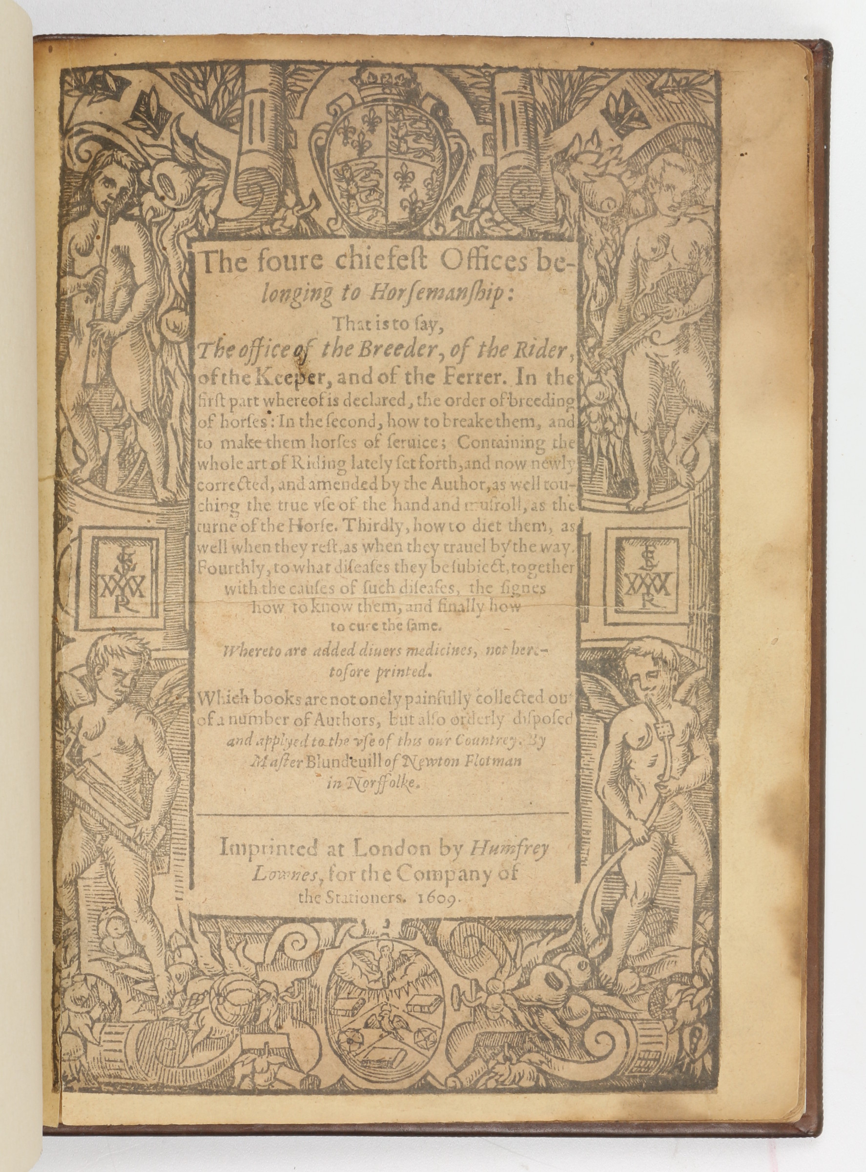
About the same time, he published The arte of ryding and breakinge greate horses, an abridged and adapted translation of Gli ordini di cavalcare by Federico Grisone a Neapolitan nobleman and an early master of dressage.
Grisone’s book was the first book on equitation published in early modern Europe and Blundeville’s translation the first in English. Blundeville followed this in 1565/6 with The fower chiefyst offices belonging to Horsemanshippe, which included a revised translation of Grisone together with other treatises.
In 1570, under the title A very briefe and profitable Treatise, declaring howe many Counsels and what manner of Counselers a Prince that will governe well ought to have. he translated into English, Alfonso d’Woa’s Italian translation of a Spanish treatise by Federigo Furio Ceriól. He now followed up with historiography, his True Order and Methode (1574) was a loose translation and summery of historiographical works by the Italians Jacopo Aconcio (c. 1520–c. 1566) and Francesco Patrizzi (1529–1597). The first work emphasised the importance of historiography as a prerequisite for a counsellor. Both volumes were dedicated to the Earl of Leicester.
In 1575 he wrote Arte of Logike, which was first published in 1599. Strongly Ramist it displays the influences Galen (129–216 CE), De Methodo (1558) of Jacopo Aconcio (c. 1520–c. 1566), Philip Melanchthon (1497–1560), and Thomas Wilson (1524–1581).
Arte of Logike Plainely taught in the English tongue, according to the best approved authors. Very necessary for all students in any profession, how to defend any argument against all subtill sophisters, and cauelling schismatikes, and how to confute their false syllogismes, and captious arguments. By M. Blundevile.
It contains a section on fallacies and examples of Aristotelian and Copernican arguments on the motion of the Earth.
This is very typical of Blundeville’s publications. He is rather more a synthesist of the works of others than an original thinker. This is very clear in his mathematical and geographical works. Blunderville published three mathematical works covering a wide range including cartography, studies in magnetism, astronomy, and navigation. The first of these works was his A Briefe Description of Universal Mappes and Cardes
This contains the following interesting passage:
For mine owne part, having to seek out, in these latter Maps, the way by sea or land to any place I would use none other instrument by direction then half a Circle divided with lines like a Mariner’s Flie [compass rose] [my emphasis]. Truly, I do thinke the use of this flie a more easie and speedy way of direction, then the manifold tracing of the Maps or Mariners Cards, with such crosse lines as commonly are drawn therein…
What Blundeville is describing here is the humble geometrical protractor, which we all used at school to draw or measure angles. This is the earliest known reference to a protractor, and he is credited with its invention.
Blundeville’s second mathematical work, is the most important of all his publications, M. Bludeville His exercises… or to give it its full title:
M. BLVNDEVILE
His Exercises, containing sixe Treatises, the titles wherof are set down
in the next printed page: which Treatises are verie necessarie to be read and learned of all yoong Gentlemen that haue not bene exercised in such disciplines, and yet are desirous to haue knowledge as well in Cosmographie, Astronomie, and Geographie, as also in the Arte of Navigation, in which Arte it is impossible to profite without the helpe of these, or such like instructions. To the furtherance of which Arte of Navigation, the said M. Blundevile speciallie wrote the said Treatises and of meere good will doth dedicate the same to all the young Gentlemen of this Realme.
This is a fat quarto volume of 350 pages, which covers a lot of territory. Blundeville is not aiming for originality but has read and synthesised the works of Martín Cortés de Albacar(1510–1582), Pedro de Medina (1493–1567), William Bourne (c. 1535–1582), Robert Norman (before 1560–after 1596), William Borough (1536–1599), Michel Coignet (1549–1623), and Thomas Hood (1556–1620) and is very much up to date on the latest developments.
The first treatise:
First, a verie easie Arithmeticke so plainlie written as any man of a mean capacitie may easilie learn the same without the helpe of any teacher.
What cause first mooved the Author to write this Arithmeticke, and with what order it is here taught, which order the contents of the chapters therof hereafter following doe plainly shew.
I Began this Arithmeticke more than seuen yeares since for a vertuous Gentlewoman, and my verie deare frend M. Elizabeth Bacon, the daughter of Sir Nicholas Bacon Knight, a man of most excellent wit, and of most deepe iudgment, and sometime Lord Keeper of the great Seale of England, and latelie (as shee hath bene manie yeares past) the most loving and faithfull wife of my worshipfull friend M. Iustice Wyndham, not long since deceased, who for his integritie of life, and for his wisedome and iustice daylie shewed in gouernement, and also for his good hospitalitie deserued great commendation. And though at her request I had made this Arithmeticke so plaine and easie as was possible (to my seeming) yet her continuall sicknesse would not suffer her to exercise her selfe therein. And because that diuerse having seene it, and liking my plaine order of teaching therein, were desirous to haue copies thereof, I thought good therefore to print the same, and to augment it with many necessarie rules meet for those that are desirous to studie any part of Cosmographie, Astronomie, or Geographie, and speciallie the Arte of Navigation, in which without Arithmeticke, as I haue said before, they shall hardly profit.
And moreover, I haue thought good to adde vnto mine Arithmeticke, as an appendix depending thereon, the vse of the Tables of the three right lines belonging to a circle, which lines are called Sines, lines tangent, and lines secant, whereby many profitable and necessarie conclusions aswell of Astronomie, as of Geometrie are to be wrought only by the help of Arithmeticke, which Ta∣bles are set downe by Clauius the Iesuite, a most excellent Mathematician, in his booke of demonstrations made vpon the Spherickes of Theodosius, more trulie printed than those of Monte Regio, which booke whilest I read at mine owne house, together with a loving friend of mine, I took such delight therein, as I mind (God willing) if God giue me life, to translate all those propositions, which Clauius himselfe hath set downe of his owne, touching the quantitie of Angles, and of their sides, as well in right line triangles, as in Sphericall triangles: of which matter, a Monte Regio wrote diffusedlie and at large, so Copernicus wrote of the same brieflie, but therewith somewhat obscurelie, as Clauius saith. Moreover, in reading the Geometrie of Albertus Durcrus, that excellent painter, and finding manie of his conclusions verie obscurelie interpreted by his Latine interpreter (for he himselfe wrote in high Dutch) I requested a friend of mine, whome I knewe to haue spent some time in the studie of the Mathematicals, not onelie plainelie to translate the foresaide Durerus into English, but also to adde thereunto manie necessary propositions of his owne, which my request he hath (I thanke him) verie well perfourmed, not onely to my satisfaction, but also to the great commo∣ditie and profite of all those that desire to bee perfect in Architecture, in the Arte of Painting, in free Masons craft, in Ioyners craft, in Carvers craft, or anie such like Arte commodious and serviceable in any common Wealth, and I hope that he will put the same in print ere it be long, his name I conceale at his owne earnest intreatie, although much against my will, but I hope that he will make himselfe known in the publishing of his Arithmeticke, and the great Arte of Algebra, the one being almost finished, and the other to bee vndertaken at his best leasure, as also in the printing of Durerus, vnto whom he hath added many necessary Geometrical conclusions, not heard of heretofore, together with divers other of his workes as wel in Geometrie as as in other of the Mathe∣maticall sciences, if he be not called away from these his studies by other affaires. In the mean time I pray al young Gentlemen and seamen to take these my labours already ended in good part, whereby I seeke neither praise nor glorie, but onely to profite my countrey.
Blundeville obviously prefers the trigonometry of Christoph Clavius over that of Johannes Regiomontanus but is well acquainted with both. More interesting is the fact that he took his geometry from Albertus Durcrus or Durerus, who is obviously Albrecht Dürer and his Underweysung der Messung mit dem Zirkel und Richtscheyt(Instruction in Measurement with Compass and Straightedge, 1525. Blundeville even goes so far as to have an English translation made from the original German (high Dutch!), as he considers the Latin translation defective.
Title page of Albrecht Dürer’s Underweysung der Messung mit dem Zirkel und Richtscheyt
The second treatise:
Item the first principles of Cosmographie, and especi∣ally a plaine treatise of the Spheare, representing the shape of the whole world, together with the chiefest and most necessarie vses of the said Spheare.
The third treatise:
Item a plaine and full description of both the Globes, aswell Terrestriall as Celestiall, and all the chiefest and most necessary vses of the same, in the end whereof are set downe the chiefest vses of the Ephemerides of Iohan∣nes Stadius, and of certaine necessarie Tables therein con∣tained for the better finding out of the true place of the Sunne and Moone, and of all the rest of the Planets vpon the Celestiall Globe.
A plaine description of the two globes of Mercator, that is to say, of the Terrestriall Globe, and of the Celestiall Globe, and of either of them, together with the most necessary vses thereof, and first of the Terrestriall Globe, written by M. Blundeuill.
This ends with A briefe description of the two great Globes lately set forth first by M. Sanderson, and the by M. Molineux.
The first voyage of Sir Francis Drake by sea vnto the West and East Indies both outward and homeward.
The voyage of M. Candish vntothe West and East Indies, described on the Terrestriall Globe by blew line.
Johannes Stadius’ ephemerides were the first ephemerides based on Copernicus’ De revolutionibus.
The fourth treatise:
Item a plaine and full description of Petrus Plancius his vniversall Mappe, lately set forth in the yeare of our Lord 1592. contayning more places newly found, aswell in the East and West Indies, as also towards the North Pole, which no other Map made heretofore hath, whereunto is also added how to find out the true distance betwixt anie two places on the land or sea, their longitudes and la∣titudes being first knowne, and thereby you may correct the skales or Tronkes that be not trulie set downe in anie Map or Carde.
This map was published under the title, Nova et exacta Terrarum Orbis Tabula geographica ac hydrographica.
Petrus Plancius’ world map from 1594
The fifth treatise:
Item, A briefe and plaine description of M. Blagraue his Astrolabe, otherwise called the Mathematicall Iewel, shewing the most necessary vses thereof, and meetest for sea men to know.
Title Page Source Note the title page illustration is an armillary sphere and not the Mathematical Jewel
The sixth treatise:
Item the first & chiefest principles of Navigation more plainlie and more orderly taught than they haue bene heretofore by some that haue written thereof, lately col∣lected out of the best modern writers, and treaters of that Arte.
Towards the end of this section, we find the first published account of Edward Wright’s mathematical solution of the construction of the Mercator chart
in the meane time to reforme the saide faults, Mercator hath in his vniuersal carde or Mappe made the spaces of the Parallels of latitude to bée wider euerie one than other from the E∣quinoctiall towards either of the Poles, by what rule I knowe not, vnlesse it be by such a Table, as my friende M. Wright of Caius colledge in Cambridge at my request sent me (I thanke him) not long since for that purpose, which Table with his consent, I haue here plainlie set downe together with the vse thereof as followeth.
The Table followeth on the other side of the leafe.
The first edition was published in 1594 and was obviously a success with a second edition in 1597, a third in 1606, and a fourth in 1613. The eighth and final edition appeared in 1638. Beginning with the second edition two extra treatises were added. The first was his A Briefe Description of Universal Mappes and Cardes. The second, the true order of making Ptolomie his Tables.
Blundeville’s Exercises contains almost everything that was actual at the end of the sixteenth century in mathematics, cartography, and navigation.
Blundeville’s final book was The Theoriques of the Seuen Planets written with some assistance from Lancelot Browne (c. 1545–1605) a friend of William Gilbert (c. 1544–1603), and like Gilbert a royal physician, published in 1602:
THE Theoriques of the seuen Planets, shewing all their diuerse motions, and all other Accidents, cal∣led Passions, thereunto belonging. Now more plainly set forth in our mother tongue by M. Blundeuile, than euer they haue been heretofore in any other tongue whatsoeuer, and that with such pleasant demonstratiue figures, as eue∣ry man that hath any skill in Arithmeticke, may easily vnderstand the same. A Booke most necessarie for all Gentlemen that are desirous to be skil∣full in Astronomie, and for all Pilots and Sea-men, or any others that loue to serue the Prince on the Sea, or by the Sea to trauell into forraine Countries.
Whereunto is added by the said Master Blundeuile, a breefe Extract by him made, of Maginus his Theoriques, for the better vnderstanding of the Prutenicall Tables, to calculate thereby the diuerse mo∣tions of the seuen Planets.
There is also hereto added, The making, description, and vse, of two most ingenious and necessarie Instruments for Sea-men, to find out thereby the latitude of any Place vpon the Sea or Land, in the darkest night that is, without the helpe of Sunne, Moone, or Starr. First inuented by M. Doctor Gilbert, a most excellent Philosopher, and one of the ordinarie Physicians to her Maiestie: and now here plainely set downe in our mother tongue by Master Blundeuile.
LONDON, Printed by Adam Islip. 1602.
A short Appendix annexed to the former Treatise by Edward Wright, at the motion of the right Worshipfull M. Doctor Gilbert.
To the Reader.
Being aduertised by diuers of my good friends, how fauorably it hath pleased the Gentlemen, both of the Court and Country, and specially the Gentlemen of the Innes of Court, to accept of my poore Pamphlets, entituled Blundeuiles Exercises; yea, and that many haue earnestly studied the same, because they plainly teach the first Principles, as well of Geographie as of Astronomie: I thought I could not shew my selfe any way more thankfull vnto them, than by setting forth the Theoriques of the Planets, vvhich I haue collected, partly out of Ptolomey, and partly out of Purbachius, and of his Commentator Reinholdus, also out of Copernicus, but most out of Mestelyn, whom I haue cheefely followed, because his method and order of writing greatly contenteth my humor. I haue also in many things followed Maginus, a later vvriter, vvho came not vnto my hands, before that I had almost ended the first part of my booke, neither should I haue had him at all, if my good friend M. Doctor Browne, one of the ordinarie Physicians to her Maiestie, had not gotten him for me…
It is interesting to note the sources that Blundeville consulted to write what is basically an astronomy-astrology* textbook. He names Ptolemy, Georg von Peuerbach’s Theoricae novae planetarum and Erasmus Reinhold’s commentary on it, Copernicus, but names Michael Mästlin as his primary source. Although Copernicus is a named source, the book is, as one would expect at the juncture, solidly geocentric. *Blundeville never mentions the word astrology in any of his astronomy texts, but it is clear from the contents of his books that they were also written for and expected to be used by astrologers.
The Theoriques contains an appendix on the use of magnetic declination to determine the height of the pole very much state of the art research.
Because the making and vsing of the foresaid Instrument, for finding the latitude by the declination of the Mag∣neticall Needle, will bee too troublesome for the most part of Sea-men, being notwithstanding a thing most worthie to be put in daily practise, especially by such as vndertake long voyages: it was thought meet by my worshipfull friend M. Doctor Gilbert, that (ac∣cording to M. Blundeuiles earnest request) this Table following should be hereunto adioined; which M. Henry Brigs (professor of Geometrie in Gre∣sham Colledge at London) calculated and made out of the doctrine and ta∣bles of Triangles, according to the Geometricall grounds and reason of this Instrument, appearing in the 7 and 8 Chapter of M. Doctor Gilberts fift booke of the Loadstone. By helpe of which Table, the Magneticall declination being giuen, the height of the Pole may most easily be found, after this manner.
It is very clear that Thomas Blundeville was a very well connected and integral part of the scientific scene in England at the end of the sixteenth century. An obviously erudite scholar he distilled a wide range of the actual literature on astronomy, cartography, and navigation in popular form into his books making it available to a wide readership. In this endeavour he was obviously very successful as the numerous editions of The Exercises show.
The Renaissance is a period of intense mathematical activity, but it is not mathematics as somebody who has studied mathematics at school today would recognise it but rather practical mathematics, that is mathematics developed and utilised within a particular practical field of work or study. It should be emphasised that this is not what we now know as applied mathematics, which is, as its name suggests, the application of an area of pure mathematics to the solution of problems in other fields. Practical mathematics is, as already stated above, mathematics that evolves whilst working on problems in a variety of field, which are susceptible to mathematical solutions. This is, of course, the province of the Renaissance Mathematicus the eponym of this blog, and as I wrote in an earlier blog post, Why Mathematicus?
If we pull all of this together our Renaissance mathematicus is an astrologer, astronomer, mathematician, geographer, cartographer, surveyor, architect, engineer, instrument designer and maker, and globe maker. This long list of functions with its strong emphasis on practical applications of knowledge means that it is common historical practice to refer to Renaissance mathematici as mathematical practitioners rather than mathematicians.
One major area of practical mathematics that bloomed and flourished in the Renaissance was surveying, as I described in detail in a post in my Renaissance science series. The root word survey has over the centuries acquired many different meanings, but it has a visual origin from the Medieval Latin supervidere “oversee, inspect,” from Latin super “over” plus videre “to see”. Renaissance land surveying is totally dependent on line-of-sight observations. The legendary straight Roman roads were so straight because the engineers laid them out from high point to high point by line of sight and then instead of going around obstacles cut through them, bridged them or whatever. Triangulation, the major advance in surveying that emerged during the Renaissance, also relies on direct line-of-sight observation from high point to high point to construct its triangles.
What, however, happens when you need to survey a territory were you literally can’t make direct line-of-sight observations? This is exactly the problem that had to be solved with the massive expansion in metal ore mining that took place during the Renaissance in eastern Europe. To solve it the miners developed their own form of practical mathematics that became known as Markscheiderkunst and its practitioners as Markscheider. Thomas Morel has written a fascinating and highly informative book, Underground Mathematics: Craft Culture and Knowledge Production in Early Modern Europe[1] that investigates the origins and evolution of this branch of practical mathematics from its origins up to the beginning of the nineteenth century.
The terms Markscheider and Markscheidekunst are German and Morel’s book concentrates on the mining history of the mining regions in Eastern Germany because that is where the then modern mining industry developed and as Morel explains the knowledge that the German miners developed was then exported all over Europe. If you wanted to start your own mining endeavours, you imported German miners. As I explained in an earlier post this is why Nürnberg developed into a major centre for the manufacture of pencils. Miners in the service of Nürnberg companies were drafted into Borrowdale in Cumbria to exploit the recently, by accident, discovered graphite deposits in the sixteenth century and brought back the knowledge of this new writing material with them when they returned home to Nürnberg.
The Markscheidekunst, ‘the art of setting limits’, comes from the German words Mark, here with the meaning of boundary, and Scheiden meaning separate, so it means the setting of boundaries, originally between mining claims and the Markscheider is the surveyor, who determines those boundaries. On the surface, no different to other surveying but determining the same boundaries under ground becomes a whole different problem, which led to the Latin translation of Markscheidekunst, geometria subterranea.
The obvious difference between the German Markscheidekunst a term of the Bergmannsprache (the miners’ dialect) and the scholars’ Latin term geometria subterranean displays a divergence between the two worlds that illustrates one of the central theses of Morel’s narrative, which begins in the first chapter.
Morel starts there where somebody, like myself, with only a superficial knowledge of Renaissance metal ore mining would expect him to start with Agricola’s De Re Metallica. The first chapter covers both the publications on mining of Georgius Agricola (1494–1555) and of Erasmus Reinhold the Younger (1538–1592), the son of the famous astronomer, Erasmus Reinhold the Elder (1511–1553). Both authors were humanist Renaissance scholars writing in Latin and Morel shows that their presentations of underground surveying don’t match with the reality of what the Markscheider were actually doing. More generally the work of the Markscheider in the Bergmannsprache was largely incomprehensible to the educated scholars.
Morel’s second chapter goes into the detail of how the Markscheider actually went about their work. Firstly, how mining claims were staked out above ground and secondly how they measured and mapped the underground mine galleries, which followed the twist and turns of the veins of metal ore. Also, how they ensured that the underground galleries didn’t extend beyond the boundaries of the claim staked out on the surface. The Markscheider developed a practical mathematical culture that was substantially different from the learned mathematical culture of the university-trained scholars. In the early decades, the world of the Markscheider was, like other trades, one of an oral tradition with apprentices learning the trade orally from a master, who passed on the knowledge and secrets of the trade. Morel traces the evolution of this oral tradition and also the failure of university trained mathematicians to comprehend it
Despite their differences to their learned colleagues in the sixteenth century, because of the economic importance of the metal ore mines the Markscheider acquired a very high social status and achieved standing at the courts in the mining districts. They became advisers to the aristocratic rulers and their expertise was requested and applied in other areas of mathematical measurement such as forestry. All of this is dealt with in detail in Morel’s third chapter.
The seventeenth century saw the development of a scribal tradition with the appearance of the manuscript Geometria subterranea or New Subterranean Geometry, allegedly written by the mining official Balthasar Rösler (1605–1673). These manuscripts evolved over the century as did the methods of surveying and the instruments used by the mine surveyors. Surprisingly this literature remained in manuscript form for most of the century only appearing in print form with Nicolaus Voigtel’s Geometria subterranea in 1686. In his fourth chapter, Morel gives a detailed analysis of this manuscript tradition and offers and explanation as to why it remained unprinted, which has to do with the way these manuscripts were used to train the apprentice surveyors.
Chapter five takes into the late seventeenth early eighteenth centuries, following the publication of Nicolaus Voigtel’s Geometria subterranea and the life and work of Abraham von Schönberg (1640–1711), Captain-general of the Saxon mining administration, and his endeavours to revive the local mining districts in the aftermath of the Thirty Years War. Central to Schönberg’s efforts was the development of the mining map of which the most spectacular example in the Freiberga subterranea, a gigantic cartography of the Ore Mountains running continuously over several hundred sheets. Ordered by Schönberg and realised by the surveyor and mine inspector, Johann Berger (1649–1695).
First sheet of the Freiberga subterranea
Morel’s sixth chapter takes the reader into the eighteenth century and the attempts to raise the academic level of the mathematical knowledge of the mine surveyors and engineers leading up to the establishment of the Bergakademien (in English, mining academies). As Morel explains these were initially not as successfully as might be supposed. Morel takes his reader through the problems and evolution of these schools for mine surveyors. He also follows the significant developments made outside such institutions, particularly by Johann Andreas Scheidhauer (1718–1784). A recurring theme is still the inability of university educated mathematicians to truly comprehend the work of the practical mathematicians in the mining industry. As Morel writes at the beginning of his summary of this chapter, “Teaching a mathematics truly useful for the running of ore mines was a daunting task that underwent important transformations during the eighteenth century.”
Morel’s final chapter is dedicated to the story of the Deep-George Tunnel, a 10 km long drainage tunnel at a depth of 284 m, which connected up numerous mines in the Harz mining district. An extraordinary project for its times. Morel shows how the planning, for this massive undertaking, was based on data recording techniques for the run of the mine galleries developed in the preceding centuries rather than new surveying. The theoretical planning was on a level not previously seen in ore mine surveying. Morel also describes in detail an interesting encounter between the practical mining engineers and a theoretical scientist. The Swiss scholar Jean-André Deluc (1727–1817) visited the area in 1776, just before the start of the project, to test the calibration of his barometers to determine altitude by descending into the depths of the mine, having previously calibrated them by ascending mountains. Impressed by the undertakings of the mining engineers he returned several times over the years observing the progress of the tunnel and reporting what he observed to the Royal Society of London.
The story of the Deep-George Tunnel is a very fitting conclusion to Morel’s narrative of the evolution of the practical mathematical discipline of subterranean surveying in the ore mines of eastern Germany. The breadth and depth of Morel’s narrative is quite extraordinary and my very brief outlines of the chapters in no way does it justice, to do so I would have to write a review as long as his book. Morel is an excellent stylist, and his book is a real pleasure to read, a rare achievement for a highly technical historical text. There are extensive footnotes packed with sources and information for further reading. There is an almost thirty-page bibliography of manuscript, printed primary, and printed secondary sources, and the book closes with an excellent index. The book is nicely illustrated with grayscale reproductions of original diagrams.
This is truly a first-class text on an, until now, relatively neglected branch of practical mathematics, which should appeal to anyone interested in the history of mathematics or the history of mining. It will also appeal to anybody interested in a prime example of the narrative history of a technical disciple that combines mathematics, technology, politics and economics.
[1] Thomas Morel, Underground Mathematics: Craft Culture and Knowledge Production in Early Modern Europe, Cambridge University Press, 2023.
Regular readers of my series of posts on English mathematical practitioners in the late sixteenth and early seventeenth centuries might have noticed the name John Davis popping up from time to time. Unlike most of the other mathematical practitioners featured here in the early modern history of cartography, navigation, and scientific instrument design, who were basically mathematicians who never or seldom went to sea, John Davis (c. 1550–1605) was a mariner and explorer, who was also a mathematician, who wrote an important and widely read book on the principles of navigation, which included the description of an important new instrument that he had designed.
Miniature engraved portrait of navigator John Davis (c. 1550-1605), detail from the title page of Samuel Purchas’s Hakluytus Posthumus or Purchas his Pilgrimes (1624) Source: Wikimedia Commons
John Davis was born and grew up in Sandridge Barton, the manor farm on the Sandrige Estate of Stoke Gabriel in Devon, a small village on the river Dart about six kilometres up-river from Dartmouth, which was an important port in the early modern period, so it seems that Davis was destined to go to sea. Amongst his neighbours, on the Sandrige Estate, were the five sons of the Gilbert-Raleigh family, Humphrey, John and Adrian Gilbert and their half brothers Carew and Walter Raleigh. Both Humphrey Gilbert (c. 1539–1583) and Walter Raleigh (c. 1552–1618) were important Elizabethan explorers and Carew Raleigh (c. 1550–c. 1625) was a naval commander. Adrian Gilbert (c. 1541–1628), who became an MP was an intimate friend of the young John Davis as was Walter Raleigh. Little is known of his childhood and youth, but we do know that he early became a friend and pupil of the leading Elizabethan mathematical practitioner, John Dee (1527–c. 1608). Davis’ friendship with the Gilbert-Raleigh brothers and John Dee would prove helpful in his first major exploration endeavour, the search for the Northwest Passage.
Stoke Gabriel SourceThe Dartmouth Town Council blue plaque erected in memory of Davis Source: Wikimedia Commons
Throughout the Middle Ages, Europe had imported good, in particular spices, from Asia via a complex, largely overland route that ended in Northern Italy, from whence the city of Nürnberg distributed them all over Europe. As the European began to venture out onto the high seas in the fifteenth century, the question arose, whether it was possible to reach Asia directly by sea? The Portuguese began to edge their way down the West African coast and in 1487/88 Bartolomeu Dias (c. 1450–1500) succeeded in rounding the southern end of Africa.
Source: Wikimedia Commons
Between 1479 and 1499 Vasco da Gama (c. 1460–1524) succeeded, with the help of an Arabic pilot, in crossing the Indian Ocean and bringing back a cargo of spices from India to Portugal. This established an initial Portuguese dominance over the oceanic route sailing eastwards to Asia, which with time they extended to the so-called Spice Islands.
Vasco da Gama Source: Wikimedia Commons
As every school kid knows, Christopher Columbus (1451–1506) believed that there was open water between the west coast of Europe and east coast of China, and that he could reach Asia faster and easier sailing west across the ocean rather the east around Africa. In 1492, he put his theory to the test and, having vastly underestimated the distance involved, just as he was running out of food, his small fleet fortuitously ran into the Americas, although they weren’t called that yet. In 1519, the Spanish seaman Ferdinand Magellan (1480–1521) proved it was possible to get past the southern tip of America and into the Pacific Ocean. The last remnants of his very battered fleet returning to Spain, without Magellan, who was killed on the way, in 1522, becoming the first people to circumnavigate the globe.
In 1577, Francis Drake (c. 1540–1596) set out to attack the Spanish on the west coast of the America, decided to return via the Pacific Ocean arriving back in England in 1580, becoming the second to circumnavigate the globe, and the first commander to survive the journey. Between 1586 and 1588, Thomas Cavendish (1560-1592), a protégé of Walter Raileigh, became the third man to circumnavigate the globe, on what was the first planned voyage to do so.
Thomas Cavendish An engraving from Henry Holland’s Herōologia Anglica (1620). Source: Wikimedia Commons
The successful circumnavigations via the southern tip of the Americas led to speculation whether it was possible to reach the Pacific Ocean by rounding the northern end of the Americas. These speculations led to the search for the so-called Northwest Passage, an endeavour in which English mariners would dominate.
Already in 1497, Henry VII sent the Italian mariner, John Cabot (C. 1450–c. 1500) to attempt to find the Northwest Passage. He is thought to have landed once somewhere on the coast of what is now Canada before returning to Bristol. In 1508, Cabot’s son Sebastian (c. 1474–1557) followed his father in trying to find the Northwest Passage. He is thought to have sailed as far north as Hudson Bay. In 1524, the Portuguese mariner, Estêvão Gomes (c. 1483–1538), who had mutinied on the Magellan circumnavigation, bringing his ship back to Spain in 1521, was commissioned by the Spanish Crown to seek a northern route through the Americas, reaching Nova Scotia before returning to Spain.
In 1551, the Muscovy Trading Company was founded in London with the specific intention of finding a Northeast Passage to China by sailing around the northern coast of Russia. A project for which they were granted exclusive rights by the English Crown. The Muscovy Company employed John Dee to teach cartography and navigation to its ships’ officers. They failed in their endeavour to find the Northeast Passage but did establish successful trading deals with Russia.
According to Charlotte Fell Smith, this portrait was painted when Dee was 67. It belonged to his grandson Rowland Dee and later to Elias Ashmole, who left it to Oxford University. Source: Wikimedia Commons
In the 1560s Humphrey Gilbert wrote a detailed treatise supporting the idea of a government supported endeavour to search for the Northwest Passage. In 1574, the privateer Martin Frobisher (c. 1535–1594) petitioned the Privy Council for permission and financial support for an expedition to find the Northwest Passage. They referred him to the Muscovy Company, who eventually agreed to licence his voyage. Altogether Frobisher undertook three attempts, in 1596 with three ships, in 1597 with a much larger fleet and finally in 1578 with a total of fifteen ships. Although he explored much of the coast and islands of Northern Canada the undertaking was basically an expensive flop. On the second expedition Frobisher’s master was Christopher Hall. Frobisher and Hall were coached by Dr John Dee in geometry and cosmography in order to improve their use of the instruments for navigation in their voyage.
Full-length life-size oil painting portrait of English explorer Martin Frobisher commissioned by the Company of Cathay to commemorate his 1576 Northwest Passage voyage and promote the planned follow-up expedition of 1577 painted by Cornelius Ketel Source:Wikimedia Commons
In 1583, Humphrey Gilbert launched an attempt, based on letters patent, that he had acquired from the crown in 1578, to establish an English colony in North America. His half-brother Walter Raleigh sailed with him but had to turn back due to lack of food on his ship. Having taken possession of Newfoundland by force, he then left again without establishing a colony due to lack of supplies. The return journey was a disaster with the loss of the biggest vessel with most of there stores and Gilbert died of blood poisoning, having stepped on a nail.
Portrait Sir Humphrey Gilbert artist unknown Source: Wikimedia Commons
The only halfway positive outcome was that Walter Raleigh received a royal charter based on Gilbert’s letters patent and would in turn go on to found, with Thomas Harriot (c. 1560–1621), as his cartography and navigation advisor, the first English colony in North America on Roanoke Island in 1584. Only halfway positive because the Roanoke colony was also a failure.
It was against this background of one hundred years of failure, from John Cabot to Martin Frobisher, to find a northwest passage that John Davis became involved in the launching of yet another expedition to find one, initiated by his childhood friend Adrian Gilbert and John Dee. Gilbert and Dee, appealed to Sir Francis Walsingham (1573–1590) Secretary of State for funding in 1583. Whilst Walsingham favoured the idea politically, no money from the state was forthcoming. Instead, the planned expedition was financed privately by the London merchant, William Sanderson (c.1548–1638).
Sanderson was trained by Thomas Allen, an assistant to the Muscovy Company, who supplied the Queen’s Navy with hemp, rope, flax, and tallow, which he imported from the Baltic countries. As a young man, Sanderson travelled with Allen throughout the Baltic, France, Germany, and the Netherlands. According to his son, he became wealthy when he inherited the family estates following the death of his elder brother. In either 1584 or 1585 he married Margaret Snedall, daughter of Hugh Snedall, Commander of the Queen’s Navy Royal, and Mary Raleigh sister to Walter Raleigh. Sanderson would go on to become Walter Raleigh’s financial manager.
Here we have once again a merchant financing exploration in the early stumbling phase of the British Empire, a concept that was first floated by John Dee and was propagated by the various members of the Gilbert-Raleigh clan. As we saw in an earlier post, it was the merchants Thomas Smith and John Wolstenholme, who later founded the East India Trading Company, who financed the mathematical lectures of Thomas Hood (1556–1620). Above, we saw that the Muscovy Trading Company financed Frobisher’s efforts to find the Northwest Passage. The founding of the British Empire was driven by trade, and it remained a trading empire throughout its existence. Trade in spices, gold, opium, tea, slaves and other commodities drove and financed the existence of the Empire.
Davis led three expeditions in search of the Northwest Passage in 1585, 1586, and 1587. He failed to find the passage but carried out explorations and surveys of much territory between Greenland and Northern Canada liberally spraying the map with the names of Sanderson, Raleigh, and Gilbert. On these voyages Davis proved his skill as a navigator and marine commander, his logbooks being a model for future mariners and although the expeditions failed in their main aim, they can certainly be counted as successful.
Map showing Davis’s northern voyages. From A life of John Davis, the navigator by Clements R. Markham, (1889) Source: Wikimedia Commons
George Clifford, 3rd Earl of Cumberland after Nicholas Hilliard Source: Wikimedia Commons
In 1591, he was part of Thomas Cavendish’s voyage to attempt to find the Northwest Passage from the western end in the Pacific. The voyage was a disaster, Cavendish losing most of his crew in a battle with the Portuguese and setting sail for home. Davis carried on to the Straits of Magellan but was driven back by bad weather, also turning for home. He too lost most of his crew on the return journey but is purported in 1592 to be the first English man to discover the Falkland Islands, a claim that is disputed.
Davis sailed as master with Walter Raleigh on his voyages to Cádiz and the Azores in 1596 and 1597. He sailed as pilot with a Dutch expedition to the East Indies between 1598 and 1600. From 1601 to 1603 he was pilot-major on the first English East India Company voyage led by Sir James Lancaster (c. 1554–1618), a privateer and trader.
James Lancaster in 1596 artist unknown Source: Wikimedia CommonsLancaster’s Ship the Red Dragon
Although a success, the voyage led to a dispute between Davis and Lancaster, the later accusing the pilot of having supplied false information on details of trading. Annoyed, Davis sailed in 1604 once again to the East Indies as pilot to Sir Edward Michelbourne (c. 1562–1609) an interloper who had been granted a charter by James I & VI despite the East India Company’s crown monopoly on trade with the East. On this voyage he was killed off Singapore by a Japanese pirate whose ship he had seized. Thus, ending the eventful life of one of Elizabethan England’s greatest navigators.
All the above is merely an introduction to the real content of this post, Davis’ book on navigation and his contribution to the development of navigation instruments. However, this introduction should serve to show two things. Firstly, that when Davis wrote about navigation and hydrography, he did so as a highly experienced mariner and secondly just how incestuous the exploration and navigation activities in late sixteenth century England were.
In 1594, Davis published his guide to navigation for seamen, which could with some justification be called Navigation for Dummies. It was the first book on navigation actually written by a professional navigator. To give it its correct title:
THE SEAMAN’S SECRETS; Deuided into 2, partes, wherein is taught the three kindes of Sayling, Horizontall, Peradoxal, and sayling vpon a great Circle: also an Horizontall Tyde Table for the easie finding of the ebbing and flowing of the Tydes, with a Regiment newly calculated for the finding of the Declination of the Sunne, and many other necessary rules and Instruments, not heretofore set foorth by any.
Newly published by Iohn Dauis of Sandrudge, neere Dartmouth, in the County of Deuon. Gent.
Imprinted at London by Thomas Dawson, dwelling at the three Cranes in the Vinetree, and are these to be solde. 1595
David Waters write, “his work gives in the briefest compass the clearest picture of the art of navigation at this time.”[1]
Davis defines his three kinds of sailing thus:
Horizontal [plane] Navigation manifesteth all the varieties [changes] of the ship’s motion within the Horizontal plain superfices [on a plane chart], where every line [meridian] is supposed parallel.
This was the traditional and most common form of navigation at the time Davis wrote his book and he devotes the whole of the first part of the book to it.
Paradoxal Navigation demonstrateth [on circumpolar charts] the true motion of the ship upon any corse assigned … neither circular nor strait, but concurred or winding … therefore called paradoxal, because it is beyond opinion that such lines should be described by plain horizontal motion.
What Davis is defining here is rhumb line or Mercator sailing.
Great circle navigation he considered as the ‘chiefest of all the three kinds of sayling’, and defined it as one ‘in whom all the others are contained … continuing a corse by the shortest distance between places not limited to any one corse.’
He lists the instruments necessary for a skilful seaman:
A sea compass, a cross staff, a quadrant, an Astrolaby, a chart, an instrument magnetical for finding the variations of the compass, an Horizontal plain sphere, a globe and a Paradoxal compass.
He then qualifies the list:
But the sea Compass, Chart and Cross Staff are instruments sufficient for the Seaman’s use … for the Cross Staffe, Compass and the chart are so necessarily joined together as that the one say not well be without the other … for as the Chart sheweth the courses, so doth the compasse direct the same, and the cross-staffe by every particular observed latitude doth informe the truth of such course, and also give the certaine distance that the ship hath sayled upon the same.
Davis describes the technique of plane (horizontal) sailing as–’the god observation of latitude, careful reckoning of the mean course steered (corrected for variation), and careful estimation of the distance run’. Of these ‘the pilot has only his height [latitude] in certain.’[2]
Davis gives clear definition of special terms such as course and traverses and delivers an example of how he wrote up his ship’s journal. His was the first book published to give such things.
Source: Waters’ The Art of NavigationSource: Waters’ The Art of Navigation
He gave much space to how to calculate the tides, including the use of ‘An Horizontal Tyde-Table,’ an instrument for calculating tide times.
Davis goes into a lot of details on how to calibrate the cross-staff, he paid particular attention to the problem of parallax produced by placing the end of the cross-staff in the wrong position on the face. This is interesting given his development of the back-staff.
In order to determine one’s latitude, it was necessary to determine the altitude of the sun at noon. This was usually done using a cross-staff, also known as a Jacob’s staff, but could also be done with a quadrant or a mariner’s astrolabe.
Source: Waters’ The Art of Navigation
The cross-staff suffered from a couple of problems. As well as the eye parallax problem, already discussed, the user had to hold the staff so that the lower tip of the traverse rested on the horizon, whilst the upper tip was on the sun, then the angle of altitude could be read off on the calibrated scale on the staff. There were different sized traverses for different latitudes and there were scales on the staff for each traverse, a topic that Davis delt with in great detail. It was difficult for the user to view both tips at the same time. Added to this the user was basically staring directly into the sun.
The cross-staff Wikimedia Commons
To get round these problems Davis invented the backstaff. At the end of the staff was a horizon vane through which the user viewed the horizon with his back to the sun. An arc, ewith a shadow vane, was attached to the staff which could slide back and forth until its shadow fell on the horizon vane the angle of altitude could be read off on the calibrated staff. This staff did not suffer from the eye parallax problem, the user only had to observe the horizon and not the sun at the same time, and the user did not have to look directly into the sun.
Source: Waters’ The Art of NavigationFigure 1 – A simple precursor to the Davis Quadrant after an illustration in his book, Seaman’s Secrets. The arc was limited to measuring angles to 45°. Source: Wikimedia Commons
Davis’ original back staff could only measure a maximum angle of altitude of 45°, which was OK as long as he was sailing in the north but was too small when he started sailing further south, so he developed a more advanced model that could measure angles up to 90°.
Source: Waters’ The Art of NavigationFigure 2 – The second Davis Quadrant after an illustration in his book, Seaman’s Secrets. The arc above is replaced with an arc below and a shadow-casting transom above. This instrument can now measure up to 90°. Source: Wikimedia Commons
This evolved over time into the so-called Davis quadrant.
Source: Waters’ The Art of NavigationFigure 3 – The Davis Quadrant as it evolved by the mid-17th century. The upper transom has been replaced with a 60° arc. Source: Wikimedia CommonsLate 17th-century engraving of Davis holding his double quadrant Source: Wikimedia Commons
Better than the cross-staff for measuring the sun’s altitude, the back-staff became the instrument of choice, particularly for English mariners for more than a century, but it was not perfect. Unlike the cross-staff, it could not be used at night to determine latitude by measuring stellar altitudes, also its use was limited by overcast weather when the sun was not strong enough to cast a shadow. To help with the latter problem, John Flamsteed replaced the shadow vane with a lens that focused the sunlight on the horizon vane instead of a shadow. The weak sunlight focused by the lens could be better seen that the faint shadow. The backstaff with lens evolved into the Hadley quadrant, which in turn evolved into the sextant still in use today.
Davis also gives an extensive description of how to navigate using a terrestrial globe. This was very innovative because mass produced printed globes were a fairly recent invention, Johannes Schöner (1477–1547) produced the first serial printed terrestrial globe in 1515, and were not easy to come by. It was Davis, who persuaded his own patron, William Sanderson, to finance Emery Molyneux’s creation of the first printed terrestrial and celestial globes in England in 1592.
Source: Waters’ The Art of Navigation
Davis emphasised that the terrestrial globe was particularly good for instruction in navigation because all three forms of sailing–plane, rhumb line, great circle–could be demonstrated on it.
In his original list of instruments for the seaman, Davis included the Paradoxal compass but he doesn’t actually explain anywhere what this instrument is. John Dee, who remember was John Davis’ teacher, also mentions the Paradoxal compass in his writings without explanation. There is talk of how he created a Paradoxal chart for Humphrey Gilbert for his fatal 1583 expedition. It turns out that the Paradoxal compass and Paradoxal chart are one and the same and that it is an azimuthal equidistant circumpolar chart, with the north pole at its centre and the lines of latitude at 10° interval as concentric circles. The azimuthal equidistant projection goes back at least to al-Bīrūnī (973–after 1050) in the eleventh century.
An azimuthal projection showing the Arctic Ocean and the North Pole. The map also shows the 75thparallel north and 60th parallel north. Source: Wikimedia Commons Davis Paradoxal compass would have covered a similar area.
In his book on plane sailing, Davis discusses the drawbacks of the plane chart or equirectangular projection, which assumes that the world is flat and on which both lines of longitude and latitude are straight equidistant parallel line which cross at right angles, which according to Ptolemaeus was invented by Marinus of Tyre (c. 70–130 CE) in about 100 CE. A plane chart is OK for comparatively small areas, the Mediterranean for example, and Davis praises its usefulness for coastal regions. However, it distorts badly the further you move away from its standard parallel.
Equirectangular projection with Tissot’s indicatrix of deformation and with the standard parallels lying on the equator Source: Wikimedia Commons
As a result, it is useless for exploration in the far north and hence the use of the Paradoxal compass. The use of such circumpolar maps became standard for polar exploration in the following centuries.
Straight forward, clear and direct The Seaman’s Secret was very popular and went through several new editions in the decades following Davis’ death. A year after it was published Davis published a second book, his The World’s Hydrographical Description or to give it its full title:
THE
WORLDES HYDROGRAPHI-
CAL DISCRIPTION.
Wherein is proved not only by Aucthoritie of Writers, but also by late experience of Travellers and Reasons of Substantial Probabilitie, that the Worlde in all his Zones, Clymats, and places, is habitable and inhabited, and the Seas likewise universally navigable without any naturall anoyance to hinder the same,
Whereby appears that from England there is a short and
speedie passage into the South Seas, to China,
Molucca, Philippina, and India, by Northerly
Navigation.
To the Renowne, Honour, and Benifit of Her Majesties State and
Communality
Published by J. DAVIS OF SANDRUG BY DARTMOUTH
In the Countie of Devon, Gentleman. ANNO 1595, May 27.
Imprinted at London
BY THOMAS DAWSON Dwelling at the Three Cranes in the Vinetree, and there to be sold.
1595.
The ‘by Northerly Navigation’ reveals that it is in fact a long plea for a return to exploration to find the Northwest Passage.
With his The Seaman’s Secrets based on his own extensive experience as an active navigator and his invention of the backstaff, John Davis made a substantial contribution to the development of mathematical navigation in the Early Modern Period.
[1] David Waters, The Art of Navigation in England in Elizabethan and Early Stuart Times, Yale University Press, New Heaven, 1958, p.201
[2] All the above is distilled from Water’s page 202.
This is the fourthin a series of discussion of selected parts of Paul Strathern’s The Other Renaissance: From Copernicus to Shakespeare, (Atlantic Books, 2023). For more general details on both the author and his book see the first post in this series.
Strathern introduces us to today’s subjects thus:
We now come to two figures who used ingenious mathematical techniques to unravel their own versions of the truth. These were Gerardus Mercator and François Viète, both of whom lived exciting lives (though not always pleasantly so), and whose works would play a part in transforming the world in which we live.
Although Mercator’s biography is well documented Strathern still manages to screw up his facts. He tells us that his father was from Gangelt and was therefore German. Gangelt was at this time in the Duchy of Jülich and the inhabitants spoke a dialect of what would become Dutch. I do wish people would look more deeply at nationality, ethnicity etc in history, just because somewhere is German or whatever today doesn’t mean it was in the sixteenth century. Then he tells us:
During Mercator’s youth, two historic events took place which would change Europe forever. Mercator was just five when Luther instigated what would become the Reformation, and he was ten years old when the survivors of Magellan’s three-year expedition to circumnavigate the globe arrived back in Seville. By this time young Mercator’s father had died, and his uncle had taken on the role of his guardian.
The Frans Hogenberg portrait of 1574, showing Mercator pointing at the North magnetic pole Source: Wikimedia Commons
Mercator was actually fifteen when his father died, and his uncle placed him in the school of the Brethren of the Common Life in ‘s-Hertogenbosch. Here Strathern drops a paragraph that brought tears to my eyes the first time I read it, not really believing what I had just read. The second time through I started weeping and the third time I just wanted to burn the whole thing down.
Even so, the main curriculum was still based on the traditional scholastic trivium of grammar, logic and rhetoric, all of which were of course taught in Latin. However, in a gesture towards the renaissance of classical knowledge, the curriculum had been extended to include Ptolemy and his Geography. The Ancient Greek polymath had written this work in Alexandria around AD 150. The fact that it was written in Ancient Greek meant that it had remained unknown to Europe during the medieval era, as scholars only knew Latin. It was not translated until 1406, when its appearance created a great stir. Meanwhile Ptolemy’s geocentric cosmology, which Aristotle had passed on, would not be refuted by Copernicus until 1543, when Mercator was in his thirties. But much of Ptolemy’s Geography, especially his map of the world – consisting of a chart which stretched from the Atlantic coast in the west to Sinae (China) in the east – had come as a revelation to the young Mercator.
Ptolemy’s Mathēmatikē Syntaxis (Almagest) and his Tetrabiblos were available and widely read in Latin in the medieval period, both of them having been translated directly from the original Greek in the twelfth century, but apparently his Geōgraphikḕ Hyphḗgēsis (Geographia) was not as, “written in Ancient Greek meant that it had remained unknown to Europe during the medieval era, as scholars only knew Latin.” This is of course total bullshit. There was no Latin translation of the Geographia in Europe in the Middle Ages because there was neither a Greek nor an Arabic manuscript of the work known before a Greek manuscript was discovered in Constantinople in the early fifteenth century and translated by Jacobus Angelus in 1406.
Meanwhile Ptolemy’s geocentric cosmology, which Aristotle had passed on [my emphasis], would not be refuted by Copernicus until 1543, when Mercator was in his thirties.
Please savour this gem of a sentence, you will probably search high and low to find its equivalent in stupidity in a supposedly serious, ‘academic’ publication. Strathern claims to be an academic author. Aristotle (384–322 BCE) passed on the geocentric cosmology of Ptolemy, written c. 150 CE!
Having imbibed Ptolemaic geography at school, Mercator now goes off to university:
In 1530, at the age of eighteen, Mercator travelled to the similarly prestigious University of Leuven. Here he passed the entry matriculation, where his name appears in the Latin form he had adopted at school followed by the classification pauperes ex castro (poor students of the castle). This indicated that he was given lodgings in one of the communal dormitories set aside for unprivileged students in the castle by the fish market. Rich students lived separately in their own rooms in a more salubrious quarter of the city.
Pauperes does in fact mean that he was a poor student but ex castro refers to the college he was in Castle College (Dutch: De Burcht or Het Kasteel, Latin: Paedagogium Castri) the oldest of the Leuven colleges, founded in 1431. All the students, rich or poor, lived in the same college building, although the quality of their rooms varied.
Strathern now slips in a reference to Vesalius:
Despite such domestic segregation, all students mingled freely, attending the same lectures, and it was here that Mercator formed a friendship with one of his more privileged contemporaries, named Andreas Vesalius, of whom we will hear more later. Suffice to say that Vesalius would become one of the great luminaries of the northern Renaissance, on a par with Mercator himself, with whom he retained a lifelong friendship.
Although they almost certainly knew each other, I know of no special friendship between Mercator and Vesalius. However, there was one between Vesalius and Gemma Frisius, about whom more soon, they even, infamously, stole part of a corpse on a gibbet together.
Having graduated MA in 1532, Mercator took himself off to Antwerp for two years, rather than progressing on to one of the higher faculties to study, theology, law, or medicine. During these two years, he took up contact with Franciscus Monachus, (c. 1490 – 1565), a Minorite friar at the monastery in Mechelen, who had earlier taught geography at the University of Leuven. Strathern introduces Monachus thus:
As we have seen, in 1494 Pope Alexander VI had brokered the Treaty of Tordesillas, which aimed to avert a dangerous clash between the two Catholic countries most involved in exploration – namely, Portugal and Spain. The pope had drawn a line north–south through the middle of the Atlantic Ocean: all land discovered to the west of this line (i.e. the New World) would belong to Spain, while all land discovered to the east of it (Africa and Asia) would belong to Portugal. Illustrating this ruling, as well as making allowances for consequent discoveries, Monachus drew two circular maps. One depicted the western hemisphere of the Americas, and the other outlined the eastern hemisphere: Africa, India and the lands to the east, which he named Alta India (in effect ‘Beyond India’). In the light of Magellan’s circumnavigation, the next obvious step was to create a model of the world in the form of a globe.
His globe, which did not survive, came first, and was constructed with the engraver Gaspard van der Heyden(c. 1496 – c. 1549). The two hemispherical maps are in an open letter describing the globe to his patron, Jean II Carondelet (1469–1545), Archbishop of Palermo, entitled De Orbis Situ ac descriptione ad Reverendiss. D. archiepiscopum Panormitanum, Francisci, Monachi ordinis Franciscani, epistola sane qua luculenta. (A very exquisite letter from Francis, a monk of the Franciscan order, to the most reverend Archbishop of Palermo, touching the site and description of the globe) in 1524.
De Orbis Situ title page Source: Wikimedia CommonsDe Orbis Situ maps showing Portuguese and Spanish hemispheres Sourec: Wikimedia Commons
Strathern now launches into a brief history of terrestrial globe-making, of which I will only give extracts that mostly need correcting:
Monachus was not the first to do this. Indeed, in line with the rebirth of classical knowledge, it was known that the Ancient Greek philosopher Crates of Mallus (now south-east Turkey) had produced a globe as early as the second century BC.
Nothing to criticise here but Strathern then goes into a discussion in which he states:
This illustrated Crates’s belief that the world consisted of five distinct climactic zones.
The climate zones or climata are, of course, standard Greek cosmography and predate Crates. First hypothesised by Parmenides and then modified by Aristotle. We move on:
A rather more accurate representation appeared during the Arab Golden Age, when in 1267 the Persian astronomer Jamal al-Din travelled to Beijing and created a terrestrial globe for Kublai Khan.
Jamal al-Din didn’t create a terrestrial globe for Kublai Khan in Beijing. When he travelled to Beijing, to become head of the Islamic Astronomical Bureau he took seven astronomical instruments of Islamic type with him, namely an armillary sphere, a parallactic ruler, an instrument for determining the time of the equinoxes, a mural quadrant, a celestial and a terrestrial globe, and an astrolabe with him.
Just prior to the geographical revolution which had taken place during Mercator’s childhood, the German navigator, merchant and map-maker Martin Behaim constructed the Erdapfel (earth apple), the earliest-known surviving globe, which followed the prevailing ideas held by Columbus, omitting any large land mass between western Europe and China.
Martin Behaim was not a navigator.
This appeared in 1492, and over the coming years it inspired a number of more accurate globes. One, constructed out of two glued-together lower halves of an ostrich egg, was among the first to include the New World. Another, cast in copper, imitated medieval maps which illustrated undiscovered regions with dragons, monsters or mythical beasts. It also labelled the unknown region to the south of China Hic sunt dracones (Here be dragons), which would become a popular appellation covering unknown regions in later maps.
Both the provenance of the Ostrich Egg Globe and its supposed date (1604) are, to say the least, disputed and I would not include it in any serious account of the history of globes.
The Ostrich Egg globe Source: Wikimedia Commons
The copper globe, that it is very similar to, is the Lenox Globe (1610) and its undiscovered regions are not illustrated with dragons, monsters, or mythical beasts. It is in fact only one of two maps known to bear the legend HC SVNT DRACONES (Latin: hic sunt dracones means here are dragons), the other is the Ostrich Egg Globe.
The Lenox Globe Source: Wikimedia CommonsNorthern hemisphere of the Lenox Globe can you see the dragons, monsters or mythical beasts? Source: Wikimedia CommonsSouthern hemisphere of the Lenox Globe can you see the dragons, monsters or mythical beasts? Source: Wikimedia CommonsThe Lenox Globe, by B.F. De Costa 1879. I can see a couple of sea creatures but no dragons, monsters or mythical beasts Source: Wikimedia commonsClose-up of the text ‘Hic Sunt Dracones’ Source: Wikimedia Commons
The handful of globes that Strathern has mentioned in his brief survey are all so-called manuscript globes i.e., they are handmade unique examples. Strathern makes no mention whatsoever of the most important development in globe history, a very significant one for Mercator, the advent of the printed globe. The earliest known printed globe, of which only sets of gores exist, was the small globe printed of the Waldseemüller world map that gave America its name.
Waldseemüller globe gores 1507
This globe was relatively insignificant is the history of the globe, the major breakthrough came with the work of the Nürnberger mathematicus, Johannes Schöner (1477–1547). Schöner went into serial production of a terrestrial globe in 1515 and a matching celestial globe in 1517.
Schöner terrestrial globe 1515, Historisches Museum Frankfurt via Wikimedia Commons Not the original stand
In the 1530s he produced a new updated pair of globes. We will return to Schöner and the influence of his globes on Mercator.
But first back to Strathern:
However, the most significant feature of these globes for Mercator was that, unlike with previous medieval maps, their geographical features were drawn or painted upon solid round surfaces. A map on a globe represented the actual size and shape of its geographical features, whereas a continuous map on a flat rectangular chart was bound to distort shapes, stretching them the further they were from the Equator [my emphasis]. The understanding of this fundamental distinction would be the making of Mercator.
That all flat maps distort was well-known to Ptolemy, who in his Geographia explicitly states that a globe is the best representation of the world. To transfer the map from the globe to a flat map one needs a projection, Ptolemy describes three different ones, and each projection, of which there are numerous, distorts differently. Strathern seems to imply here that there is only one map projection and the distortion that he describes here is that of the Mercator projection!
But first of all he [Mercator] would have to understand the complexities of maps and globes.
These he learned from a curious character by the name of Gemma Frisius…
[…]
Although only four years older than Mercator, at this stage he may well have taught Mercator mathematics.
Gemma Frisius 17th C woodcut E. de Boulonois Source: Wikimedia Commons
Why is Gemma Frisius (1508–1555) a curious character? Strathern gives no explanation for this statement. There is also no ‘may well’ about it, when Mercator returned to Leuven in 1534 after his two-year time-out, he spent two years studying geography, mathematics, and astronomy under Gemma Frisius’ guidance. He also in this period learnt the basics of instrument and globe making from Frisius. Strathern now delivers up a very garbled and historically highly inaccurate account of how Frisius and Mercator became globe makers.
Around 1530, when Frisius was in his early twenties, a local goldsmith called Gaspar van der Heyden produced ‘an ingenious all-in-one terrestrial/celestial globe’. This incorporated a geographical map of the world, on which were also inscribed the main stars of the heavens. Such was the complexity of this muddled enterprise that it required a three-part booklet to explain how to understand it. The task of writing this was assigned to Frisius, and its title gives an indication of the difficulties involved: On the Principles of Astronomy and Cosmography, with Instruction for the Use of Globes and Information on the World and on Islands and Other Places Recently Discovered.
What actually happened is somewhat more complex. Schöner had become a highly successful globe maker and his globes were being sold over all in Europe. However, there was a greater demand than he could supply.
Jean II Carondelet, the Archbishop of Palermo, who as we saw above was Franciscus Monachus’ patron and dedicatee of his De Orbis Situ, commissioned the Antwerp printer/publisher Roeland Bollaert, who had printed the De Orbis Situ, to reprint Schöner’s Appendices in opusculum Globi Astriferi, in 1527, and the engraver Gaspard van der Heyden was commissioned to engrave the celestial globe to accompany it. In 1529, Gemma Frisius edited an improved second edition of Peter Apian’s Cosmographia, which was printed and published by Roeland Bollaert. Gemma Frisius, who had earlier studied under Monarchus, began to work together with Gaspar van der Heyden, and it was Gemma Frisius who created the ‘ingenious all-in-one terrestrial/celestial globe’, which van der Heyden engraved. Gemma wrote the accompanying booklet Gemma Phrysiusde Principiis Astronomiae & Cosmographiae deque usu globi ab eodem editi (1530), which was published by the Antwerp publisher Johannes Graheus. It is probably that Roeland Bollaert had died in the meantime. In this book Gemma Frisius acknowledges his debt to Johannes Schöner. Monarchus had also acknowledged his debt to both Schöner and Peter Apian in his De Orbis Situ. Gemma Frisius and van der Heyden later produced a new pair of globes, 1536, terrestrial and 1537, celestial, and this time Mercator was employed to add the cartouches in italic script to the globes, his introduction to globe making.
Strathern now tells us about Gemma Frisius’ book and its influence on Mercator:
Within this cornucopia of often extraneous knowledge were to be found the sound principles which Frisius would later pass on to Mercator. Most importantly, these involved such vital cartographic elements as the principles of longitude and latitude, which form a network covering the surface of the globe. The lines of longitude are drawn down the surface of the globe at regular intervals from the North Pole to the South Pole.* As long as a ‘meridian’ or middle point (line zero) is established, it is possible to record how far one’s position lies east or west of this line from pole to pole. By this time, navigators were beginning to carry shipboard clocks. As a rough-and-ready method for discovering how far east (or west) they had travelled from their home port, they could measure the time discrepancy between noon on the shipboard clock (i.e. noon at their home port) and noon at their current location (the sun’s zenith).
* Both of these were of course theoretical concepts at the time, conjectured from the fact that a globe must have a top (northernmost point) and a bottom (southernmost point.) It would be some five centuries before the existence of the actual poles was confirmed by discovery.
The lines of latitude are drawn around the globe, beginning at its widest girth (the Equator), and then ascending in regular diminishing circles towards the North Pole, and also descending at regular intervals to the South Pole. In order to establish their longitude, navigators had learned to measure the precise location above the horizon of stars in the sky. This also could be compared to their location when at the home port. Such measurements were taken with an astrolabe (literally ‘star taker’), the forerunner of the sextant.
Reading these atrocious paragraphs, I asked myself why do I bother? Why don’t I just throw the whole thing in the next trash can and walk quietly away? However, being a glutton for punishment, I persevere. But where to begin? I will start with the origins of the longitude and latitude system, at the same time dealing with the mind bogglingly stupid starred footnote.
Most people don’t realise but the longitude and latitude system of cartographical location was first developed in astronomy to map the skies. In the northern hemisphere, if you look up into the night sky, the heavens appear to form a sphere around the Earth and there are stars that every night circle the same point in the heavens, that point is the astronomical north pole. In fact, as we now know it’s the Earth that turns not those circumpolar stars, but for our mapping purpose that is irrelevant. The astronomical or celestial north pole is of course directly above the terrestrial north pole, on a straight line perpendicular to the plane of the equator. You can observe the same phenomenon in the southern hemisphere, defining the south celestial and terrestrial poles, but as the European astronomers could not see the heavens further south than the Tropic of Capricorn, that doesn’t need to concern us at the moment. Note the north and south poles are not theoretical concepts but real points on both the celestial and terrestrial spheres. The lines of longitude are the theoretical great circles around the celestial sphere passing through the north and south poles. The annual path of the Sun defines the Equator and the Tropics of Cancer and Capricorn, the principal lines of latitude. The Poles, the Equator, and the two Tropics are the principal features on the armillary sphere, the earliest three-dimensional model of the celestial sphere created by astronomers, sometime around the third century BCE.
Diagram of an armillary sphere with the Poles, the Equator, and the two Tropics Source: Wikimedia Commons
At some point somebody had the clever idea of shrinking this handy mapping network down from the celestial sphere on to the terrestrial sphere, the Earth. The first cartographer to use longitude and latitude for terrestrial maps was probably Eratosthenes (C. 276–c. 195 BCE). His prime meridian (line of longitude) passed throughAlexandria and Rhodes, while his parallels (lines of latitude) were not regularly spaced, but passed through known locations, often at the expense of being straight lines. (Duane W. Roller, Eratosthenes Geography, Princeton University Press, 2010 pp. 25–26). Hipparchus (c. 190–c. 120 BCE) was already using the same system that we use today. Ptolemy, of course, used the longitude and latitude system in his Geographia, in fact a large part of the book consists of tables of longitude and latitude from hundreds of places from which it is possible to reconstruct maps. If as Strathern claims, Mercator studied the Geographia at school then he didn’t need Gemma Frisius to explain longitude and latitude to him.
Strathern’s “By this time, navigators were beginning to carry shipboard clocks. As a rough-and-ready method for discovering how far east (or west) they had travelled from their home port, they could measure the time discrepancy between noon on the shipboard clock (i.e. noon at their home port) and noon at their current location (the sun’s zenith) can only be described as a historical cluster fuck! Dave Sobel’s Longitude (Walker & Company, 1995), for all its errors, and it has many, which tells the story of how John Harrison (1693–1776) produced the first marine chronometer, that is a clock accurate and reliable enough under testing condition to enable the determination of longitude, his H4 in 1761, was almost certainly the biggest popular history of science best-seller ever! Apparently, Strathern has never heard of it!
The whole is much, much worse when you know that the first person to hypothesise the determination of longitude using an accurate mechanical clock was Gemma Frisius and he did so in Chapter nine of his On the Principles of Astronomy and Cosmography, the only one of his publications that Strathern mentions:
… it is with the help of these clocks and the following methods that longitude is found. … observe exactly the time at the place from which we are making our journey. … When we have completed a journey … wait until the hand of our clock exactly touches the point of an hour and, at the same moment by means of an astrolabe… find out the time of the place we now find ourselves. … In this way I would be able to find the longitude of places, even if I was dragged off unawares across a thousand miles.
Gemma Frisius was, however, of the difficulties that the construction of such a clock would involve:
… it must be a very finely made clock which does not vary with change of air.
More than a hundred years later the French astronomer Jean-Baptiste Morin (1583–1656), who propagated the lunars method of determining longitude wrote:
I do not know if the Devil will succeed in making a longitude timekeeper but it is folly for man to try
Strathern is not much better on latitude, The lines of latitude are drawn around the globe, beginning at its widest girth (the Equator), and then ascending in regular diminishing circles towards the North Pole, and also descending at regular intervals to the South Pole. In order to establish their longitude [sic, I assume that should read latitude!] navigators had learned to measure the precise location above the horizon of stars in the sky. This also could be compared to their location when at the home port. Such measurements were taken with an astrolabe (literally ‘star taker’), the forerunner of the sextant. Latitude is determined by measuring either the height of the Sun, during the day, or the Pole Star, at night. That’s why in marine slang the daytime measurement is called “shooting” the sun. As David King is fond of repeating, the astrolabe was never used for navigation. It is possible that fifteenth century navigators used a mariner’s astrolabe, but more likely that they used a quadrant or a Jacob’s staff. Frisius’ lifetime is too early for the backstaff, which was first described by John Davis (c.1550–1605) in his The Seaman’s Secrets in 1594. It is the backstaff that was the forerunner of the sextant not the astrolabe.
A Jacob’s staff, from John Sellers’ Practical Navigation (1672) Source: Wikimedia Commons
The errors continue:
In order to prepare the maps for incorporation on the globe, they first had to be copied to a uniform scale so that they could be aligned with other maps. All this required a sophisticated understanding of the maps involved, and required the use of geometry, trigonometry and especially triangulation.
This last method enabled the map-makers to calculate the precise location of a distant geographical feature – such as a mountain, town or river mouth – using the known location of two other features. The modern version of this method was invented by Frisius in 1533, and worked as follows. First a line of known length was drawn between two features (Brussels and Antwerp in Frisius’s early experiment). Then the surveyor would draw a line from each end of the known line directly towards the unlocated feature (Middelberg, in Frisius’s case) and measure the angles between these lines and the ends of the known line. This gave him a triangle with a base of known length, and two base angles. From these it was a simple matter of geometry to ‘triangulate’ the distances to and position of the unlocated feature.
Gemma Frisius was indeed the first to describe triangulation in the third edition of Apian’s Cosmographia in 1533 but Strathern’s account of how it works is arse backwards. Triangulation is a trigonometrical method of surveying, which is then used to draw maps. First you have to accurately measure your baseline on the ground, in Gemma Frisius’ example between Brussels and Antwerp. Then from the two endpoints the angles of observation of a third point, Middelburg in Gemma’s example, are measured enabling the completion of the triangle on the drawing board and thus the determination of the distances between the endpoints of the baseline and the third point using trigonometry. Gemma Frisius’ example is purely theoretical as you can’t actually see Middelburg from either Brussels or Antwerp.
Gemma Frisius triangulation example from 3rd edition Apian/Frisius Cosmographia Source: Wikimedia Commons
Strathern devotes some time to Mercator’s biography, his setting up as an independent cartographer and instrument maker and his marriage, then delivers the next piece of history of cartography ignorance:
A year later, in 1538, he produced his first etched map of the world, Orbis Imago. This map is highly ingenious in its representation of the globe on a flat surface. The map is in two parts, which join at a tangent. The first part views the world from above the North Pole, the second from above the South Pole. But instead of showing two semicircles, each view is a rounded heart-shape with an indentation curving in towards the pole. This tearing-apart of the semicircle enabled Mercator to represent the land masses without the distorted exaggeration which would have occurred if the maps had stretched to contain two semicircles. A cut-out of these two-dimensional shapes can be twisted and folded into a semblance of a three-dimensional globe, and there is no doubt that Mercator had something similar in mind. When presented in this form, a flat map of the world did not distort the land masses; however, it also did not provide an accurate picture of the distances between various geographical features so was of little use to mariners.
Mercator Orbis Imago Source: Wikimedia Commons
Mercator’s Orbis Imago is a double cordiform (heart shaped) polar projection and Strathern seems to think that Mercator invented it, he didn’t. The cordiform projection is also known as the Stab-Werner projection named after Johannes Stabius (1540–1522), who invented it and Johannes Werner (1468–1522), who first published/publicised it, in his partial translation of Ptolemy’s Geographia (1514). The two mathematici were friends, who knew each other from their mutual time at the University of Ingolstadt. Both Peter Apian in 1530 and the French mathematicus Oronce Fine (1494–1555) in 1531 produced single cordiform projection world maps, of which Mercator was almost certainly aware as the sixteenth century, European, cartography scene was strongly networked.
Peter Apian cordiform world map 1530 Source: British LibraryOronce Fine cordiform world map 1534 Source: Wikimedia Commons
More importantly in 1532 Oronce Fine also produced a double cordiform polar projection world map and Mercator’s Orbis Imago is fairly obviously merely an improved version of Fine’s map.
The Stab-Werner projection is Equal-area i.e., area measure is conserved everywhere and Equidistant i.e., all distances from one (or two) points are correct. It was never intended for use by mariners.
Apart from its geometric ingenuity, Mercator’s Orbis Imago has two other features of note. The view over the South Pole includes a large-scale representation of Antarctica, which he named Terra Australis Incognita (Unknown Southern Land). According to historical records, neither Australia nor Antarctica had yet been discovered by Europeans; however, the existence of such a land mass had long been a theoretical supposition – considered a necessary counterbalance to the land masses of the northern hemisphere.
The Terra Australis Incognita first appeared in the sixteenth century on the globes of Johannes Schöner and it has been shown that Oronce Fine took the details for his maps from Schöner’s work and that Mercator took his from Fine.
Mercator’s map also included the word ‘America’ as a name for the large land mass to the west of Europe.
The German map-maker Martin Waldseemüller had been the first to use the name ‘America’ on a map, in 1507. This labelled a large island, straddling the Equator, which he had named after Amerigo Vespucci, the Florentine explorer whose voyages had provided extensive mapping of the south-east coast of this territory which Vespucci first named the New World.
However, in later maps new evidence had led Waldseemüller to take a more tentative view of Vespucci’s claims, and he replaced ‘America’ with the inscription ‘Terra Incognita’, suggesting that the Terra de Cuba discovered by Columbus was in fact an eastern part of Asia. Mercator’s labelling of America, as well as his clear outlining of the northern and southern parts of this landmass, confirmed once and for all this name.
There now follows a long biographical section that I won’t comment on; I’m only here for the history of cartography. We now arrive at the ominous 1569 world map, and what is probably the worst account of the Mercator projection that I have ever read.
From now on Mercator buried himself in his work. His ambition was no less than to produce a complete map of the world which could be used by navigators.
Throughout history, large-scale maps had usually been centred upon a known location. For instance, Ptolemy’s map was centred on the Mediterranean. Later maps, such as the large round medieval Mappa Mundi,* had Jerusalem as their centre, with the known world radiating outwards from this central holy point. Mercator decided that his map would have no centre. Instead it would be projected onto a grid of longitude and latitude lines – which would become known as Mercator’s projection. On a globe these lines are curved, but on Mercator’s flat surface they were rectilinear straight lines. This inevitably stretched the scale of the map the further it moved from the Equator. For instance, on Mercator’s map the Scandinavian peninsula appeared to be three times the size of the Indian subcontinent, whereas in fact India is one and a half times larger than Scandinavia. But this would in no way hamper navigation, which relied upon location established by lines of latitude and longitude. A ship could sail across an ocean following a constant compass bearing. This may have appeared curved on Mercator’s flat map, but owing to the bulge of the globe it did in fact represent the most direct route.
Ptolemy’s world map in not centred on the Mediterranean; the Mediterranean lies in the top half of the map on the lefthand side.
A printed map from the 15th century depicting Ptolemy’s description of the Ecumene by Johannes Schnitzer (1482). Source: Wikimedia Commons Note the longitude and latitude grid
The starred footnote to “the large round medieval Mappa Mundi,” “*This remains on public display at Hereford Cathedral in England,” seems very strongly to imply that Strathern thinks there was only ever one large round medieval Mappa Mundi, which is of course total rubbish.
Mercator’s infamous 1596 map is centred on the Atlantic Ocean setting a standard for European world maps that would lead to the cartographers being accused of politically portraying the world from a Eurocentric standpoint.
Mercator world map 1569 Source: Wikimedia Commons
Projecting a map on to a grid of longitude and latitude lines is not the Mercator projection. The printed Ptolemaic world maps of the late fifteenth century are projected on to a grid of longitude and latitude lines (see above), as are the world maps of John Ruysch (1507), Martin Waldseemüller (1507), Francesco Rosseli (1508), Dürer-Stabius (1515), Peter Apian (1530) and Oronce Fine (1536) all on various map projections.
On a globe these lines are curved, but on Mercator’s flat surface they were rectilinear straight lines. This inevitably stretched the scale of the map the further it moved from the Equator.
This is rubbish! In order to have a map on which a loxodrome or rhomb line is a straight-line Mercator systematically widened the distance between the lines of latitude towards the north and south poles, according to a set mathematical formular, which he didn’t reveal. Strathern makes no mention of Pedro Nunes (1520–1578), who first determined the rhumb line as the course of constant bearing on a globe was a spiral, the basis of Mercator’s work. Mercator had drawn rhumb line spirals on his globe from 1541.
A ship could sail across an ocean following a constant compass bearing. This may have appeared curved on Mercator’s flat map, but owing to the bulge of the globe it did in fact represent the most direct route.
Once again Strathern is spouting rubbish. As already stated above on the Mercator projection a course of constant compass bearing, the rhumb line, is a straight-line, the whole point of the projection, and it does not represent the most direct route. The most direct route is the arc of the great circle of the globe that passes through the point of departure and the destination. However, to sail such a course means having to constantly change the compass bearing, so although longer the course of constant compass bearing is easier to navigate.
A rhumb line (blue) compared to a great-circle arc (red) between Lisbon, Portugal and Havana, Cuba. Top: orthographic projection. Bottom: Mercator projection. Jacob Run Source. Wikimedia Commons
Yet what happened when a ship travelled beyond the edge of the map? If a ship set sail from China, heading east across the Pacific Ocean, it would soon reach the limit. But if the navigator rolled the map into a cylinder, with the eastern edge of the map attached to the western edge, the solution to this problem was obvious. The navigator could simply continue from the eastern border of the map across the Pacific to the west coast of America. In this he would also be aided by corresponding map references on lines of longitude and latitude.
This is simply cringe worthy. If someone was sailing from China across the Pacific to the west coast of America, they would use a chart of the Pacific for the voyage.
From now on navigators would adopt Mercator’s projection, both for continental and for local charts. The entire world had become ‘orientated’. Originally this word meant ‘aligned to the east’; on Mercator’s projection the world was aligned north, south, east and west, by means of longitude and latitude. And any point on this flattened globe could be pinpointed, as if on a graph, by reading off its precise position in numbers along the lines of longitude and latitude. Dangerous shoals, rocks, river mouths, cities and towns, mountains, borders and even entire countries could be mapped and ‘orientated’. Mercator completed his task in 1569, and to this day Mercator’s projection is how we envisage the world when it is mapped onto a flat surface.
Nobody adopted the Mercator projection in 1569 because Mercator did not explain how to construct it. It first came into use at the end of the century when Edward Wright (1581–1626) revealed the mathematics of the Mercator projection in his Certaine Errors in Navigation (1599).Even then the take up of the Mercator projection for marine charts was a slow process only really becoming general in the early eighteenth century. Strathern still seems to be under the illusion that the cartographical longitude and latitude grid somehow originated with Mercator, whereas by the time Mercator created his 1569 world map it had been in use for about eighteen centuries. The Mercator projection is only one of numerous ways thatwe envisage the world when it is mapped onto a flat surface and there is in fact a major debate which projection should be used. The use of alongitude and latitude grid does not necessarily imply that a map has to have north at the top.
But Mercator’s task was not complete. For the next twenty-six years he painstakingly created more than a hundred maps, all scaled according to his projection. During the final years of his life he started binding these together with the intention of making them into a book. For the front cover he planned to have an engraving of the Ancient Greek Titan named Atlas, kneeling, with the world balanced on his shoulders. Hence the name which would come to be attached to such compilations of maps.
Mercator did not start binding his maps together with the intention of making them into a book during the final years of his life. His Atlas was part of a major complex publishing project, beginning in 1564, when he began compiling his Chronologia, which was first published in 1569:
The first element was the Chronologia, a list of all significant events since the beginning of the world compiled from his literal reading of the Bible and no less than 123 other authors of genealogies and histories of every empire that had ever existed. (Wikipedia)
The Chronologia developed into an even wider project, the Cosmographia, a description of the whole Universe. Mercator’s outline was (1) the creation of the world; (2) the description of the heavens (astronomy and astrology); (3) the description of the earth comprising modern geography, the geography of Ptolemy and the geography of the ancients; (4) genealogy and history of the states; and (5) chronology. Of these the chronology had already been accomplished, the account of the creation and the modern maps would appear in the atlas of 1595, his edition of Ptolemy appeared in 1578 but the ancient geography and the description of the heavens never appeared. (Wikipedia)
The maps, that would eventually appear posthumously in his Atlas, were not drawn using the Mercator projection, which is totally unsuitable for normal regional maps. The Atlas was not named after the Titan, who carried the world on his shoulders, but after a mythical king of Mauretania credited with creating the first globe, who Mercator described in the preface to his 1589 map collection, “Italiae, Sclavoniae, Grecia”, thus “I have set this man Atlas, so notable for his erudition, humaneness, and wisdom as a model for my imitation.” The name Atlas was first used on the 1595 posthumous map collection Atlas Sive Cosmographicae Meditationes de Fabrica Mundi et Fabricati Figura, published by his son Rumold Mercator (1541–199). King Atlas was first replaced on the cover by the Titan Atlas in later edition in the seventeenth century.
Cover of Atlas Sive Cosmographicae Meditationes de Fabrica Mundi et Fabricati Figura (facsimile) Showing King Atlas of Mauretania
Having royally screwed up the life and work of Mercator, Strathern now turns to the French jurist and mathematician François Viète (1540–1603).
François Viète (1540–1603). Source: Wikimedia Commons
Having started Viète’s biography Strathern delivers this gem:
In 1564, Viète’s mathematical skills led to him entering the service of the Parthenay family, so that he could act as tutor to the twelve-year-old mathematical prodigy Catherine de Parthenay. Together they wrote a number of treatises on astronomy and trigonometry. In these, Viète used decimal notation several decades before this was introduced to the northern Renaissance by the Dutch mathematician Simon Stevin.
Decimal notation had been in use for a couple of centuries before Viète came along, what he tried to introduce without success was the use of decimal fractions.
After lots more biographical detail covering Viète’s political involvements, we get the following.
Viète had become involved in a dispute over the new calendar with the Jesuit monk Christopher Clavius, who had been charged with overseeing its compilation. Such was the subtlety of Viète’s mathematical argument that it was not until more than twenty years later (after his death) that a flaw was discovered in Viète’s calculations.
The Jesuits are an apostolic and not a monastic order, so Christoph Clavius is not a monk. Clavius was not charged with compiling the Gregorian Calendar, but with explicating and defending it after it had been introduced. Viète attacked both the new calendar and Clavius in a series of pamphlets in 1600, in particular the calculation of the lunar cycle. He gave a new timetable, which Clavius refuted, after Viète’s death, in his Explicatio in 1603. I don’t know but in my world from 1600 to 1603 is not twenty years.
What is more surprising is that, during the course of his hectic royal employment, he managed to produce a body of transformative mathematics. In this, Viète attempted to give algebra a foundation as rigid as that of the geometry of Euclid, whose theorems were built upon a number of self-evident axioms.
Viète did try to give algebra a new foundation but the analogy with Euclid’s Elements is badly chosen. The Elements, with its axiomatic approach, is the epitome of the synthetic proof methodology in mathematics. What Viète started was on the way to setting up algebra as the epitome of the analytical proof methodology; in fact, it was Viète, who replaced the term algebra with the term analysis.
At the same time he advocated the viewing of geometry in a more algebraic fashion. Instead of the necessarily inexact measurement with a ruler of lines, curves and figures drawn on paper, these were to be reduced to algebraic formulas, thus enabling them to be calculated in algebraic fashion, giving precise numerical answers.
This is a misrepresentation of what Viète actually did. He revived the geometric algebra that can be found in Euclid’s Elements. Here problems and theorems that we would present algebraically are handled as geometrical constructions. This is the reason why in our terminology x2 is referred to as x squared and an equation with x2 is a quadratic equation. For Euclid x is literally the side of a square or quadrate and x2 is its area. Similarly, x3 is the volume of a cube of side length x, hence the terms x cubed and cubic equation. Viète took this route because he wanted to demonstrate that the variables in an algebraic expression could represent geometrical objects, such as a line segment, and not just numbers. He didn’t develop these thoughts very far.
As we have seen, in the previous century Regiomontanus had attempted a similar standardization of algebra – but this had not become widely accepted.
Now Viète would attempt his own fundamental transformation of algebra. This branch of mathematics still largely consisted of a number of algorithms: rules of thumb to be followed in order to find the answer to a calculation. These had been set down in prose form – as indeed had all algebraic formulas. For instance: ‘In order to obtain the cubic power, multiply the unknown by its quadratic power.’ In modern notation, this can be simply put:
y x y2 = y3
Unfortunately Viète was hampered by the lack of an agreed symbol for ‘equals’ (=), as well as agreed symbols for ‘multiplication’ (x) and ‘division’ (÷) – which had also hampered acceptance of Regiomontanus’s notation. However, although Viète’s attempt to rationalize algebraic notation failed to gain widespread acceptance, it made many realize that such reform was long overdue.
The transformation of algebra from rhetorical algebra, in which everything is expressed purely in words, to symbolic algebra, in which symbols are used to express almost everything, had been taking place step for step for a couple of centuries, in the form of syncopated algebra which uses a mixture of words, abbreviations, and symbols in its expressions, before Viète made his contribution As is mostly the case in the evolution of science this was not a smooth linear progress but often a case of two steps forward and one step back. With his In artem analyticem isagoge (Introduction to the art of analysis) in 1591, Viète made a significant and important contribution to that progress. His major contribution was the introduction of letters, vowels, such as A, for variables and consonants, such as Z, for parameters in algebraic expressions. Strathern is correct is saying that Viète lacked symbols for some operators. Interestingly our equals sign, =, had been in use in Northern Italy for some time and had famously been introduced into Northern Europe by Robert Recorde (c. 1512–1558) in his Whetstone of Witte in 1557.
Viète In artem analyticem isagoge Source: MacTutor
Viète actually managed a ‘one step back’ in his Isagoge. In an earlier step in syncopated algebra quadrate had been abbreviated to q and cube to c, so A2 was written Aq and A3 as Ac. A later development was to drop the abbreviation and write A2 as AA and A3 as AAA, an important step towards our use of superscripts to indicate the multiplicity of a variable. Viète reverted to using the abbreviations q and c. His Isagoge found quite a high level of acceptance; Regiomontanus’ notation, however, found no acceptance because it never existed!
More ambitiously, Viète pressed ahead with his attempt to unite algebra and geometry, though here too any general answer eluded him. But Viète’s efforts were not to be in vain. The very fact that he had attempted such innovations would reinforce the movement of maths in the direction of its modern incarnation, where solutions to both these problems would be found.
Waffle!
It would be the following century when Descartes managed to solve such problems, with the introduction of Cartesian coordinates: two lines at right angles, one representing the x-axis and the other the y-axis. Here the answers to an algebraic formula could be transformed into a line on a graph; likewise geometric lines could be seen as algebraic formulas.
Here we are talking about the creation of analytical geometry, which was developed independently, but contemporaneously, by both Pierre Fermat (1607–1665) and René Descartes (1596–1650). Fermat, who was according to his own account influenced by Viète, circulated his Methodus ad disquirendam maximam et minimam et de tangentibus linearum curvarum, based on work from 1629, in manuscript from 1636, although it was first published, posthumously in 1679. It was less influential in analytical geometry, Descartes having garnered the laurels, but had an important influence on the development of calculus, as acknowledged by Newton.
Fermat Methodus ad disquirendam maximam et minimam et de tangentibus linearum curvarum, Source: Royal Astronomical Society
Descartes, for whom no influence by Viète has been determined, famously published his La Géométrie, as an appendix to his Discours de la méthode in 1637.
Descartes La Géométrie Source: Wikimedia Commons
The real impact of the work coming with the publication of the second, expanded, Latin edition by Frans van Schooten Jr (1615–1660) in 1649. You can search La Géométrie, as much as you want but you won’t find any trace of an orthogonal, Cartesian coordinate system, as used today. This was first introduced by Frans van Schooten in the Latin edition.
The resemblance between these coordinates and the lines of latitude and longitude which Mercator drew on his maps is indicative. It was in this way that Mercator, and to a certain extent Viète, enabled the northern Renaissance to lay the foundations for our present world view. It was they who sought to devise a coordinated representation of our modern physical world in geography, and pointed the way to our modern theoretical world of multidimensional mathematics.
Well at least Strathern recognises that a longitude and latitude grid as used by Mercator is an orthogonal, coordinate system but as is fairly clear from this final paragraph he definitely suffers from the illusion that Mercator invented the orthogonal longitude and latitude grid, which is simply historical hogwash.
If someone was intending to write an essay about Gerard Mercator, one might think that they would first acquaint themselves with an extensive knowledge of cartography and its history, in which Mercator played a highly significant role. Paul Strathern apparently didn’t feel this was necessary and obviously didn’t bother, the result is a steaming heap of bovine manure masquerading as history.
Today I’m continuing my occasional series on the English mathematical practitioners of the Early Modern Period. In the post in this series about Edmund Gunter (1581–1626) I quoted the historian of navigation David Waters as follows:
Gunter’s De Sectore & Radio must rank with Eden’s translation of Cortes’s Arte de Navegar and Wright’s Certain Errors as one of the three most important English books ever published for the improvement of navigation.[1]
I have already written about Richard Eden (c. 1520–1576) back in 2021, so today I am turning my attention to the third of Water’s trio of navigation improvers, Edward Wright (1561–1615).
As is fairly obvious from the David Waters quote, Edward Wright is one of the most important figures in the history of, not just English but European, navigation during the Early Modern Period. However, as is, unfortunately, all to often the case with mathematical practitioners from this period, we have very little biographical detail about his life and can only fill the gaps with speculation.
The younger son of Henry and Margaret Wright, he was baptised in the village of Garveston in Norfolk on 8 October 1561. His father, a man of “mediocrisfortunae” (modest means), was already deceased, when his elder brother Thomas entered Gonville and Caius College, Cambridge as a pensioner in 1574. Edward was probably educated by John Hayward at Hardingham school, like his elder brother, and also entered Gonville and Caius College, as a sizar, a student who earns part of his fees by working as a servant for other students, in December 1576. Unfortunately, Thomas died early in 1579. Edward graduated BA in the academic year 1580-81 and MA in 1584. He became a fellow of Gonville and Caius in 1587 and resigned his fellowship in 1596, having married Ursula Warren (died 1625) 8 August 1595. Oxbridge fellows were not permitted to marry. They had a son Thomas Wright (1596–1616), who was admitted sizar at Gonville and Caius in 1612.
Wright’s career in Cambridge parallels that of another significant mathematical practitioner born in the same year, Henry Briggs (1561–1630). Briggs went up to St John’s College in 1577, graduated BA in 1581 or 1582 and MA in 1585. He was awarded a fellowship in 1588. The two became friends and interacted over the years up till Wright’s death.
Henry Briggs
Another acquaintance of Wright’s, who he possibly got to know at Cambridge, was the aristocrat Robert Devereux (1565–1601), who graduated MA at Trinity College Cambridge in 1581, and who had succeeded to the title of Earl of Essex in in 1576 at the death of his father. Devereux, a soldier, was incredibly well connected in Elizabethan society becoming a favourite at Elizabeth’s Court and so would initially have been a good contact for the commoner Wright. However, he was still a close friend of Wright’s when he rebelled against Elizabeth at the end of the century, which could have proved dangerous for the mathematical practitioner, but apparently didn’t.
Melancholy youth representing the Earl of Essex, c.1588, miniature by Nicholas Hilliard Source: Wikimedia Commons
Another soldier and a good friend of Devereux’s, who also became a friend of Wright’s at Cambridge, was the astronomer and astrologer, Sir Christopher Heydon (1561–1623), who graduated BA in 1589 at Peterhouse Cambridge.
Sir Christopher Hendon’s birth horoscope
What we don’t know is who taught Edward Wright mathematics at Cambridge and how, why, and when he became deeply interested in navigation and cartography, which he very obviously did, whilst still at the university. The interest in sea voyages and all things navigational associated with them was very strong in England in the latter part of the sixteenth century, with England beginning to flex its deep-sea muscles and challenge the Spanish Portuguese duopoly on marine exploration and discovery, particularly following the defeat of the Spanish Armada in 1588. This could well have been Wright’s motivation as a mathematical practitioner to follow the lead of other practitioners such as John Dee (1527–1608/9) and Thomas Harriot (c. 1560–1621) and specialise in navigation.
That Wright had taken up the study of navigation and already acquired a substantial reputation is indicated by the Royal Mandate, issued by Elizabeth in 1589, instructing Gonville and Caius College to grant Wright leave of absence to carry out navigational studies on a raiding expedition to the Azores under the command of Sir George Clifford, 3rd Earl of Cumberland (1588–1605).
George Clifford, 3rd Earl of Cumberland after Nicholas Hilliard Source: Wikimedia Commons
Cumberland was sailing as what is known as a privateer, which means piracy licensed by the Crown in exchange for a share of the profits. Sailing to the Azores, on the way Cumberland seized French Catholic league and Flemish vessels. In the Azores he attacked both the islands and various Portuguese and Spanish vessels making rich killings. Up till now, the expedition was a success, but the return journey was pretty much a disaster. Hit by storms many of the crew died of hunger and thirst on the return journey and the English ship the Margaret was shipwrecked off the coast of Cornwall. All the while Wright was carrying out his navigational studies. On the voyage he was accompanied by Richard Hues (1553–1632) a cartographical and navigational pupil of Thomas Harriot and one of the Wizard Earl’s mathematici. He also became acquainted with the navigator and explorer John Davis (c. 1550–1605).
Miniature engraved portrait of navigator John Davis (c. 1550-1605), detail from the title page of Samuel Purchas’s Hakluytus Posthumus or Purchas his Pilgrimes (1624) Source: Wikimedia Commons
Wright recorded his experiences of the Azores’ voyage in his most important publication: Certaine Errors in Navigation, arising either of the Ordinarie Erroneous Making or Vsing of the Sea Chart, Compasse, Crosse Staffe, and Tables of Declination of the Sunne, and Fixed Starres Detected and Corrected. (The Voyage of the Right Ho. George Earle of Cumberl. to the Azores, &c.), London: Printed … by Valentine Sims.
Edward Wright’s map “for sailing to the Isles of Azores” (c. 1595), the first to be prepared according to his projection Source: Wikimedia Commons
Another version of the work published in the same year was entitled: Wright, Edward (1599), Errors in nauigation 1 Error of two, or three whole points of the compas, and more somtimes, by reason of making the sea-chart after the accustomed maner … 2 Error of one whole point, and more many times, by neglecting the variation of the compasse. 3 Error of a degree and more sometimes, in the vse of the crosse staffe … 4 Error of 11. or 12. minures in the declination of the sunne, as it is set foorth in the regiments most commonly vsed among mariners: and consequently error of halfe a degree in the place of the sunne. 5 Error of halfe a degree, yea an whole degree and more many times in the declinations of the principall fixed starres, set forth to be obserued by mariners at sea. Detected and corrected by often and diligent obseruation. Whereto is adioyned, the right H. the Earle of Cumberland his voyage to the Azores in the yeere 1589. wherin were taken 19. Spanish and Leaguers ships, together with the towne and platforme of Fayal, London: Printed … [by Valentine Simmes and W. White] for Ed. Agas.
Before we turn to the navigational errors that Wright illuminated in his book, it also contains another piece of interesting information. Wright states that he sailed with Cumberland under the name Edward Carelesse. When he introduces himself in the book, he also states that he sailed with Sir Francis Drake, as Captain of the Hope, on his West Indian voyage of 1585-86, which evacuated Sir Walter Raleigh’s Virginia colony and brought the survivors back to England. Wright would have had the opportunity to make the acquaintance of Thomas Harriot, who was one of the rescued colonists. Capt. Walter Bigges and Lt. Crofts’ book A Summarie and True Discourse of Sir Frances Drakes West Indian Voyage (1589) confirms that Edward Carelesse was commander of the Hope. This voyage would fit into the gap between Wright’s MA, 1585 and the start of his fellowship in 1587.
The principal navigational error that Wright’s book addresses, and the reason why it is so important, is the problem of sailing the shortest route between two places on a sea voyage. In the early phase of European deep-sea exploration, mariners adopted the process of latitude sailing. Mariners could not determine longitude but could determine latitude fairly easily. Knowing the latitude of their destination they would sail either north or south until they reached that latitude and then sail directly east or west until they reached their desired destination. This was by no means the most direct route but prevented getting lost in the middle of the ocean.
The actual shortest route is a great circle, that is a circumference of the globe passing through both the point of departure and the destinations. However, it is very difficult to sail a great circle using a compass as you have to keep adjusting your compass bearing. Although not as short, far more practical for mariners would be a course that is a constant compass bearing, such a course is known as a rhumb line, rhumb, or loxodrome:
In navigation, a rhumb line, rhumb, or loxodrome is an arc crossing all meridians of longitude at the same angle, that is, a path of constant bearing as measured relative to true north. (Wikipedia)
Image of a loxodrome, or rhumb line, spiraling towards the North Pole Source: Wikimedia Commons
The first to analyse the mathematics of rhumb lines, which takes the form of a spiral on the surface of a sphere, was the Portuguese mathematical practitioner Pedro Nunes (1502–1578) in his Tratado em defensam da carta de marear (Treatise Defending the Sea Chart), (1537).
Pedro Nunes, 1843 print Source: Wikimedia Commons
Nunes determined that a course of constant bearing would be a rhumb, but he did not solve the problem of how to construct a marine chart on which a rhumb line would be a straight-line enabling navigators to simply read off the required compass bearing from the chart. This problem was first solved by the Flemish globe maker and cartographer, Gerard Mercator (1512–1594), who was friends with Nunes, with the publication of his world map of 1569, which introduced for the first time what is now known as the Mercator projection on which a course of constant compass bearing is a straight line.
Gerhard Mercator, Kupferstich von Frans Hogenberg, 1574 Source: Wikimedia Commons
Mercator explained in simple terms how he had achieved this, “We have progressively increased the degrees of latitude towards each pole in proportion to the lengthenings of the parallels with reference to the equator” but gave no exact mathematical prescription how to produce such a chart.
Mercator World Map 1569 Source: Wikimedia Commons
Both John Dee (1527–1609?), who personally knew Pedro Nunes and studied cartography under Mercator’s teacher Gemma Frisius (1508–155) and Thomas Harriot (c. 1560–1621) solved the problem of how to mathematically construct the Mercator projection. However, although both of them taught cartography and navigation, Dee to the captains of the Muscovy Trading Company and Harriot to Walter Raleigh’s captains, neither of them made their solution public. Enter Edward Wright.
Wright took up the problem of the marine chart and rhumb lines where Pedro Nunes had stopped, openly acknowledging his debt to Nunes in the preface to his Certaine Errors in Navigation:
Cover of Wright’s Certaine Errors Source: Wikimedia Commons
Yet it may be, I shall be blamed by some, as being to busie a fault-finder myself. For when they shall, see their Charts and other instruments controlled which so long time have gone for current, some of them perhappes will scarcely with pacience endure it. But they may be pacified, if not by reason of the good that ensueth hereupon, yet towards me at the least because the errors I poynt at in the chart, have beene heretofore poynted out by others, especially by Petrus Nonius, out of whom most part of the first Chapter of the Treatise following is almost worde for worde translated;
He goes on to solve the problem of constructing the Mercator projection:
By help of this planisphaere with the meridians, rumbes, and parallels thus described therein, the rumbs may much more easily & truly be drawn in the globe then by these mechanical wayes which Petrus Nonius [Pedro Nunes] teacheth cap. 26 lib. 2 de obser. Reg. et Instr. Geom..
The problem that Wright solved is that as one proceeds north or south from the equator the circles of latitude get progressively smaller but when one unwraps the globe on the surface of a cylinder in the Mercator projection all the lines of latitude need to be the same length so that they cross all lines of latitude at right angles.
The Mercator projection shows rhumbs as straight lines. A rhumb is a course of constant bearing. Bearing is the compass direction of movement. Source: Wikimedia Commons
Wright’s principle was very simple: to increase the distance apart of the parallels of latitude to match the exaggeration arising from the assumption that they were equally long. Since the lengths of the parallels varied according to a factor cos λ, the correction factor was sec λ at any point. In order to plot the parallels on the new charts, Wright had effectively to perform the integration’ sec λdλ. This was done numerically—in his own words, “by perpetual addition of the Secantes answerable to the latitudes of each point or parallel into the summe compounded of all the former secantes. . . .,” (P. J. Wallace, Dictionary of Scientific Biography)
To save others having to repeat the protracted and tedious numerical iterations that he had carried out, Wright published a table of the necessary correcting factors for the distance between the lines of latitude. In the first edition of the book this table was only six pages long and contained the correction factors for every 10 minutes of latitude. In the second edition of the book, Certaine Errors in Navigation, Detected and Corrected with Many Additions that were not in the Former Edition…, published in London in 1610, the table had grown to 23 pages with factors for every minute of latitude.
Cover of Wright’s Certaine Errors second edition 1610 Source
The emergence of both Wright’s book and his method of constructing the Mercator projection into the public sphere is rather complex. He obviously wrote the major part of the manuscript of the book when he returned to Cambridge in 1598 but there are sections of the book based on observation made in London between 1594 and 1597. Wright’s development of the Mercator projection was first published, with his consent, in Thomas Blundevile’s His Exercises containing six Treatises in 1594, the first publication in English on plane trigonometry, he wrote:
[the new (Mercator) arrangement, which had been constructed] “by what rule I knowe not, unless it be by such a table, as my friende M.Wright of Caius College in Cambridge at my request sent me (I thanke him) not long since for that purpopse which table with his consent. I have here plainlie set down together with the use of thereof as followeth”. The table of meridiional parts was given at degree intervals.
The so-called “Christian Knight map”, published by Flemish map-maker Jodocus Hondius in Amsterdam in 1597. To produce the map, Hondius made use of Edward Wright’s mathematical methods without acknowledgement. Source: Wikimedia Commons
Although he wrote a letter of apology to Wright, Wright condemned him for it in the preface to Certaine Errors:
“But the way how this [Mercator projection] should be done, I learned neither of Mercator, nor of any man els. And in that point I wish I had beene as wise as he in keeping it more charily to myself”
Hondius was by no means the only one to publish Wright’s method before he himself did so. William Barlow (1544–1625) included in his The Navigator’s Supply (1597) a demonstration of Wright’s projection “obtained of a friend of mone of like professioin unto myself”.
In 1598–1600 Richard Hakluyt published his Principle Navigations which contains two world charts on the new projection, that of 1600 a revision of the first. Although not attributed to Wright it is clear that they are his work.
The title page of the first edition of Hakluyt’s The Principall Navigations, Voiages, and Discoveries of the English Nation (1589) Source: Wikimedia CommonsWright’s “Chart of the World on Mercator’s Projection” (c. 1599), otherwise known as the Wright–Molyneux map published in Hakluyt’s The Principall Navigations Source: Wikimedia Commons
Earlier, the navigator Abraham Kendall had borrowed a draft of Wright’s manuscript and unknown to Wright made a copy of it. He took part in Drake’s expedition to the West Indies in 1595 and died at sea in 1596. The copy was found in his possessions and believing it to be his work it was brought to London to be published. Cumberland showed the manuscript to Wright, who, of course recognised it as his own work.
Wright first publicly staked his claim to his work when he finally published the first edition of Certaine Errors in 1599. A claim that he reinforced with the publication of the second, expanded edition in 1610. However, it should not be assumed that mariners all immediately began to use Mercator projection sea charts for navigating. The acceptance of the Mercator marine chart was a slow process taking several decades. As well the method of producing the Mercator projection, Certaine Errors also includes other useful information on the practice of navigation such as a correction of errors arising from the eccentricity of the eye when making observations using the cross-staff, tables of declinations, and stellar and solar observations that he had made together with Christopher Haydon. The work also includes a translation of Compendio de la Arte de Navegar (Compendium of the Art of Navigation, 1581, 2nd ed., 1588) by the Spanish cosmographer Rodrigo Zamorano (1542–1620).
It is not clear how Wright lived after he had resigned from his fellowship. There are suggestions that he took up the position of Mathematicall Lecturer to the Citie of London when Thomas Hood resigned from the post after only four years in 1592. However, there is no evidence to support this plausible suggestion. Wright’s friend, Henry Briggs, was appointed the first Gresham professor of geometry in 1596, a position to hold public lectures also in London, which may have made the earlier lectureship superfluous. However, Wright was definitely employed by Thomas Smith and John Wolstenholme, who had sponsored Hood’s lectureship, as a lecturer in navigation for the East India Company at £50 per annum, probably from 1612 but definitely from 1614. Before his employment by the East India Company, he had been mathematical tutor to Prince Henry (1594–1612), the eldest son of King James I/IV, from about 1608, to whom he dedicated the second edition of Certaine Errors.
In the 1590s Wright was one of the investigators whose work contributed to William Gilbert’s De Magnete(1600) for which he wrote the opening address on the author and according to one source contributed Chapter XII of Book IV, Of Finding the Amount of Variation…
Source
In this context he also wrote, Description and Use of the Two Instruments for Seamen to find out the Latitude … First Invented by Dr. Gilbert, published in Blundeville, Thomas; Briggs, Henry; Wright, Edward (1602),The Theoriques of the Seuen Planets… a work on the dip circle.
He also authored The Description and Vse of the Sphære. Deuided into Three Principal Partes: whereof the First Intreateth especially of the Circles of the Vppermost Moueable Sphære, and of the Manifould Vses of euery one of them Seuerally: the Second Sheweth the Plentifull Vse of the Vppermost Sphære, and of the Circles therof Ioyntly: the Third Conteyneth the Description of the Orbes whereof the Sphæres of the Sunne and Moone haue beene supposed to be Made, with their Motions and Vses. By Edward Wright. The Contents of each Part are more particularly Set Downe in the Table first published in London in 1613 with a second edition in 1627. This could be viewed as a general introduction to the armillary sphere, but was actually written was a textbook for Prince Henry. A year later he published A Short Treatise of Dialling Shewing, the Making of All Sorts of Sun-dials, Horizontal, Erect, Direct, Declining, Inclining, Reclining; vpon any Flat or Plaine Superficies, howsoeuer Placed, with Ruler and Compasse onely, without any Arithmeticall Calculationprobably also written for the Prince.
As well as the translation of Zamorano’s Compendio de la Arte de Navegar included in his Certaine Errors, he translated Simon Stevin’s The Hauen-finding Art, or The VVay to Find any Hauen or Place at Sea, by the Latitude and Variation. Lately Published in the Dutch, French, and Latine Tongues, by Commandement of the Right Honourable Count Mauritz of Nassau, Lord High Admiral of the Vnited Prouinces of the Low Countries, Enioyning all Seamen that Take Charge of Ships vnder his Iurisdiction, to Make Diligent Obseruation, in all their Voyages, according to the Directions Prescribed herein: and now Translated into English, for the Common Benefite of the Seamen of England, a text on determining longitude using magnetic variation.
In 1605, he also edited Robert Norman’s translation out of Dutch of The Safegarde of Saylers, or Great Rutter. Contayning the Courses, Dystances, Deapths, Soundings, Flouds and Ebbes, with the Marks for the Entring of Sundry Harboroughs both of England, Fraunce, Spaine, Ireland. Flaunders, and the Soundes of Denmarke, with other Necessarie Rules of Common Nauigation.
His most important work of translation was certainly that of John Napier’s Mirifici Logarithmorum Canonis Descriptio (Description of the Wonderful Canon of Logarithms, 1614) from the original Latin into English: A Description of the Admirable Table of Logarithmes: With a Declaration of the … Use thereof. Invented and Published in Latin by … L. John Nepair … and Translated into English by … Edward Wright. With an Addition of an Instrumentall Table to Finde the Part Proportionall, Invented by the Translator, and Described in the Ende of the Booke by Henry Brigs, etc approved by Napier and first published posthumously by Henry Briggs in 1616 and then again in 1618.
The development of mathematical navigation, cartography, and surveying in the Early Modern Period, in which Wright along with others played a central role, was by nature predominantly trigonometrical. Napier’s invention of logarithms made the complex trigonometrical calculations much easier to manage. This was something that Napier himself was acutely aware of and the majority of tables in his work were, in fact, logarithms of trigonometrical functions. By translating Napier’s work into English, Wright made it accessible to those mariners confronted with trigonometrical navigational problems, who couldn’t read Latin. The introduction contains the following poem:
The toylesome rules of due proportion
Done here by addition and subtraction,
By tripartition and tripartition,
The square and cubicke roots extraction:
And so, all questions geometricall,
But with most ease triangles-sphericall.
The use in great in all true measuring
of lands, plots, buildings, and fortification,
So in astronomy and dialling,
Geography and Navigation.
In these and like, yong students soon may gaine
The skilfull too, may save cost, time, & paine.
Wright was also acknowledged as a skilled designer of scientific instruments, but like his friend Edmund Gunter (1561–1626), he didn’t make them himself. He is known to have designed instruments for the astronomer/astrologer Sir Christopher Haydon and to have made astronomical observations with him in London in the early 1590s. We don’t know Wright’s attitude to astrology, but that of his two Cambridge friends was diametrically opposed. Haydon was the author of the strongest defence of astrology written in English in the early seventeenth century, his A Defence of Judiciall Astrologie (1603), whereas Henry Briggs was one of the few mathematical practitioners of the period, who completely rejected it, unlike John Napier who as an ardent supporter.
Wright’s work in navigation was highly influential on both sides of the North Sea.
Wright gets positively acknowledge, both in The Navigator (1642) by Charles Saltonstall (1607–1665) and in the Navigation by the Mariners Plain Scale New Plain’d (1659) by John Collins (1625–1683).
In England Wright’s work was also taken up by Richard Norwood (1590? –1675), the surveyor of Bermuda, who using Wright’s methods determined one degree of a meridian to be 367,196 feet (111,921 metres), surprisingly accurate, publishing the result in his The Seaman’s Practice, 1637. However, in his Norwood’s Epitomy, being the Application of the Doctrine of Triangles, 1645, he gives a clear sign that the Mercator chart still hasn’t been totally accepted 46 years after Wright first published the solution of how to construct it.
Although the ground of the Projection of the ordinary Sea-Chart being false, (as supposing the Earth and Sea to be plain Superficies [sufaces]) and so the conclusions thence derived must also for the most part erroneous; yet because it is most easy, and much used, and the errors in small distances not so evident, we will not wholly neglect it.
He actually devotes as much space, in this work, which continued to be published throughout the century in various editions, to plain sailing as he does to Mercator sailing. Interestingly in the section on Mercator sailing, he doesn’t, following Wright, just give a table of meridional parts but explains how to use trigonometry to calculate them.
Now that which he [Edward Wright] hath shewed to performe by the Chart it selfe [the table of meridional parts], we will shew to work by the Doctrine of plaine Triangles, using the helpe of the Table of Logarithme Tangents…
Although its impact was drawn out over several decades it is impossible to over emphasise Wright’s contribution to the histories of cartography and navigation by his publication of the mathematical means of constructing a Mercator chart.
[1] David Walters, The Art of Navigationin England in Elizabethan and Early Stuart Times, Yale University Press, 1958 p. 359
The so-called European Age of Discovery is usually considered to have begun as adventurers from the Iberian Peninsular began to venture out into the Atlantic Ocean in the fifteenth century, reaching a high point when Bartolomeu Dias (c. 1450–1500) first rounded the southern tip of Africa in 1488 and Christopher Columbus (1441–1506) accidentally ran into the Americas trying to reach the Indies by sailing west. Those who made successful voyages, basically meaning returned alive, passed on any useful information they had garnered to future adventurers. It would be first at the end of the sixteenth century that the governments of the sea faring nations first began to establish central, national schools of navigation that accumulated such navigational and cartographical knowledge, processed it, and then taught it to new generations of navigators. Through out the sixteenth century individual experts were hired to teach these skills to individual groups setting out on new voyages of discovery.
In England this function was filled by Thomas Harriot (c. 1560–1621), who not alone taught navigation and cartography to Walter Raleigh’s sailors but also sailed with them to North America, making him that continent’s first scientist. John Dee (1527–c. 1608) supplied the same service to the seamen of the Muscovy Trading Company, although, unlike Harriot, he did not sail with them. Richard Hakluyt (1553–1616), a promotor of voyages of discovery, collected, collated, and published much information on all the foreign voyages but only passed this information on in manuscript to Raleigh.
In the 1580s Dee disappeared off to the continent, Harriot after returning from the Americas disappeared into the private service of Henry Percy, 9th Earl of Northumberland (1564–1632) and Hakluyt, a clergyman, after returning from government service in Paris, investigating the voyages of the continental nations, went into private service. In Paris, in 1584, Hakluyt noted that there was a lectureship for mathematics at the Collège Royal and wrote a letter to Sir Francis Walsingham (c. 1532–1590), the Queen’s principal secretary, the most powerful politician in England and a major supporter of voyages of discovery. In his letter, Hakluyt, urged Walsingham to establish a lectureship for mathematics at Oxford University for scholars to study the theory of navigation and the application of mathematics to its problem, and a public lectureship of navigation in London to educate seamen.
Walsingham undertook nothing and the demand grew loud for some form of public lectureship in mathematics to supply the necessary mathematics-based information in navigation and cartography to English seamen. In 1588, a private initiative was launched by Sir Thomas Smith (c. 1558–1625), Sir John Wolstenholme (1562–1639), and John Lumley, 1st Baron Lumley and Thomas Hood (1556–1620) was appointed Mathematicall Lecturer to the Citie of London.
Thomas Hood, baptised 23 June 1556, was the son of Thomas Hood a merchant tailor of London. He entered Merchant Taylors’ School in 1567 and matriculated at Trinity College Cambridge in 1573. He graduated BA c. 1578, was elected a fellow of Trinity and graduated MA in 1581. He was granted a licence to practice medicine by Cambridge University in 1585 and, as already mentioned, lecturer for mathematics in London in 1588. This appointment and his subsequent publications indicate that he was a competent mathematical practitioner but from whom he learnt his mathematics is not known.
Before turning to Hood’s lectureship and the associated publications, it is interesting to look at those who sponsored the lectureship. Thomas Smith was the son and grandson of haberdashers and like Hood attended Merchant Taylors School, entering in 1571.
Source: Wikimedia Commons
He entered the Worshipful Company of Haberdashers and the Worshipful Company of Skinners in 1580 and went on to have an impressive political career in the City of London, occupying a series of influential posts over the years. His father had founded the Levant Trading Company and Thomas was the first governor of the East India Company, when it was founded in 1600, but only held the post for four months having fallen into suspicion of being involved in the Essex Rebellion. He was reappointed governor in 1603 and with one break in 1606-7 remained in the post until 1621. Later, he was a subscriber to the Virginia Company, as was Hood, and obtained its royal charter in 1609 and became the new colony’s treasurer making him de facto non-resident governor until his resignation in 1620. His grandfather had founded the Muscovy Company and Smith also became involved in that. It’s easy to see why Smith was motivated to promote a lectureship in practical mathematics.
John Wolstenholme was cut from a very similar cloth to Smythe, son of another John Wolstenholme a customs’ official in London, he became a rich successful merchant at an early age.
An effigy of Sir John Wolstenholme (1562 – 1639), carved by master stone mason to Charles I, Nicholas Stone, for the old St John the Evangelist Church, Great Stanmore Source: Wikimedia Commons
Like Smythe a founding member of both the East India and Virginia Companies, he was also a strong supporter of the attempts to find the North-West Passage. He fitted out several of the expeditions, Henry Hudson (c. 1556–disappeared 1611) named Cape Wolstenholme, the extreme northern most point of the province of Quebec after him. William Baffin (c. 1584–1622) named Wolstenholme Island in Baffin Bay after him.
John Lumley was slightly different to the two powerful merchants, a member of the landed gentry, he was an art collector and bibliophile.
John Lumley 1st Baron Lumley portrait attributed to Steven van de Meulen Source: Wikipedia Commons
In the same year 1582, that the three founded Hood’s mathematical lectureship, Lumley founded with Richard Caldwell (1505?–1584), a physician, the Lumleian Lectures. Initially intended to be a weekly lecture course on anatomy and surgery they had been reduced to three lectures a year by 1616. They still exist as a yearly lecture on general medicine organised by the Royal College of Physicians.
The mathematical lectures finally came into being in 1588, following the threat of the Spanish Armada in that year. The original intended audience consisted of the captains of the city’s train bands or armed militia but also open to the ship’s captains, who rapidly became the main audience. The lectures were on geometry, astronomy, geography, hydrography, and the art of navigation. The lectures were originally held in the Staplers’ Chapel in Leadenhall Street but later moved to Smith’s private residence in Gracechurch Street, where he had held the inaugural lecture. In total Hood lectured for four years and later he attempted to obtain license to practice medicine in London from the Royal College of Physicians. This was denied him due to his inadequate knowledge of Galen. He was finally granted a conditional licence in 1597 and sometime after that he moved to Worcester, where he practiced medicine until his death in 1620.
His first publication was his inaugural lecture under the title, A COPIE OF THE SPEACHE:MADE by the Mathematicall Lecturer, unto the Worshipful Companye present. At the house of the Worshipfull M. Thomas Smith, dwelling in Gracious Street: the 4. of November, 1588. T. Hood. Imprinted at London by Edward Allde.
In this lecture he set out the reasons for the establishment of the lectureship and emphasised the importance of mathematics to people in all walks of life. He also sketched a history of mathematics from Adam down to his own times. The lectures were obviously successful, and he was urged to publish them, which he did to some extent.
His next major publication was The VSE OF THE CELESTIAL GLOBE IN PLANO; SET FOORTH IN TWO HEMISPHERES: WHEREIN ARE PLACED ALL THE MOST NOTa[ble] Starres of the heauen according to their longitude, latitude, magnitude, and constellation: Whereunto are annexed their names, both Latin Greeke, and Arabian or Chaldee; … (1590) They don’t write title like that anymore.
There is also an advert explaining that one can buy the hemispheres from the author at his address. He explains that he has presented the celestial spheres in plano in order to make it easier for seamen to read off the longitude and latitude of stars than it would be from a small globe. His beautifully coloured planispheres are the first printed planispheres in England. A seaman who bought Hood’s planispheres no longer needed to buy a celestial globe or planispheric astrolabe.
Thomas Hood celestial sphere in plano northern hemisphere SourceThomas Hood celestial sphere in plano southern hemisphere Source
Before he published The Use of the Celestial Globe, he published a pamphlet on the use of a novel cross-staff that he had devised. Hood’s cross staff was a significant step towards the back staff, which eliminated the necessity of looking directly into the sun to take readings. This was so successful that he was urged to produce a similar pamphlet for the Jacobs Staff, and he obliged publishing two pamphlets in 1590,The vse of the two Mathematicall instrumentes, the crosse Staffe … and the Iacobes Staffe in two parts with separate titles. The pamphlets attracted the attention of the Lord Admiral, Lord Howard (1536–1624), who became his patron. Hood dedicated a second edition of the double pamphlet to Howard in 1596.
Thomas Hood cross staff Source: Wikimeia Commons
Hood’s finally publication of 1590 was a translation of The Geometry of Petrus Ramus, THE ELEMENTES OF GEOMETRIE: Written in Latin by that excellent Scholler, P. Ramus, Professor of the Mathematical Sciences in the Vuniverstie of Paris: And faithfully translated by Tho. Hood, Mathematicall Lecturer in the Citie of London. Knowledge hath no enemie but the ignorant.
Like many others in this period, Hood’s books were written in the form of dialogues between a master and a student, and he continued in this form with his next book on the use of globes in 1592. Serial production printed celestial and terrestrial globes had been in existence on the continent since Johannes Schöner (1477–1547) had produced the first pair in the second decade of the sixteenth century but none had been produced in England. Probably at the suggestion of John Davis (c. 1550–1605), a leading Elizabethan navigator, the London merchant William Sanderson (c. 1548–1638) commissioned and sponsored the instrument maker Emery Molyneux (died 1598) to produce the first English printed pair of globes, in the early 1590s. The globe gores were printed by the Flemish engraver Jodocus Hondius (1563–1612), at the time living in exile in London, who would go on to found one of the two largest publishing houses for maps and globes in Europe in the seventeenth century.
Sanderson request Hood to write a guide to the use of such globes and Hood complied publishing his THE VSE of both the Globes, Celestiall,and Terrestriall, most plainely deliuered in forme of a Dialogue. Containing most pleasant, and profitableconclusions forthe Mariner, and generally for all those, that are addicted to these kinde of mathematicall instrumentes in 1592.
In the same year Hood edited a new edition of the popular navigation manual A Regiment for the Sea by William Bourne (c. 1535–1582) which was originally published in 1574. Hood edition would be printed in two further editions.
In 1598 Hood published his The Making and Use of the Geometricall Instrument called a sector, the first printed account of this versatile instrument, which almost certainly informed the much more extensive account of the sector by Edmund Gunter (1581–1626) published in 1624.
Astronomical sector, 16th-century artwork. This device was used to make accurate observations of the position of an object in the sky, such as a star or the Sun. The sight (lower left) would be used to line up the hinged rulers (right) with the object being observed. The position of the star was recorded as an angle from the vertical or horizontal, as read from the curved area (left). Artwork from ‘The making and use of the geometricall instrument, called a sector’ (1598) by Thomas Hood.
Hood’s most peculiar publication was an English translation of the Elementa arithmeticae, logicis legibus deducta in usum Academiae Basiliensis. Opera et studio Christiani Urstisii originally published in 1579. Christiani Urstisii was the relatively obscure Swiss mathematician, theologian, and historian Christian Wurstisen (1544–1588).
Why Hood stopped his lectures after four years in nor clear, he seems to have been both popular and successful and later Smith and Wolstenholme would later employ Edward Wright (1561–1615), who we will meet again in the next post in this series, through the East India Company in the same role. However, after he ceased lecturing Hood continued to sell instruments and his hemisphere charts. Hood’s lectureship was an important step towards the professional teaching of navigation to mariners in England at the end of the sixteenth century.
If your philosophy of [scientific] history claims that the sequence should have been A→B→C, and it is C→A→B, then your philosophy of history is wrong. You have to take the data of history seriously.
John S. Wilkins 30th August 2009
Culture is part of the unholy trinity—culture, chaos, and cock-up—which roam through our versions of history, substituting for traditional theories of causation. – Filipe Fernández–Armesto “Pathfinders: A Global History of Exploration”