
On 9 March the British Library Prints & Drawings Twitter account (@BL_prints) tweeted the following, accompanied by the illustration.
This is the first scientific map of the moon and was produced in Paris by astronomer Giovanni Domenico Cassini. Working in the 1670s, Cassini used a telescope to make careful observations of the moon’s surface.

Source: British Library
This is of course historical rubbish Cassini’s being by no means the first ‘scientific’ map of the moon and I thought who ever runs the @BL_prints Twitter account really ought to up their historical game then I followed the link to the British Library website and discovered the following text:
This is the first scientific map of the moon and was produced in Paris by astronomer Giovanni Domenico Cassini. Working in the 1670s, Cassini used a telescope to make careful observations of the moon’s pock-marked surface. Thanks to the map, 17th-century European scientists had a greater understanding of the moon than they did of much of the Earth’s surface.
If you look very carefully at the map, you will find a ‘Moon Maiden’ hiding behind one of the craters. It seems that either Cassini, or the map’s famous engraver Claude Mellan, included the detail, believing that this tiny part of the moon’s surface looked like a beautiful woman.
Somebody at the British Library really needs to improve their knowledge of the history of astronomy in general and of selenography in particular. For anybody who doesn’t already know, selenography is the science of the physical features of the moon. Selenography is to the moon what geography is to the earth.
Interestingly the first scientific map of the moon was made before the invention of the telescope by William Gilbert (1540–1603) some time before1603. It was, however first published in the text De Mondo Nostro Sublunari in Amsterdam in 1651. No attempts to accurately draw the surface of the moon have survived from antiquity or the Middle Ages if they ever existed. Gilbert also regretted that no such drawing from antiquity existed because he would have liked to compare and contrast in order to see if the moon had changed over time. Although made without the assistance of a telescope the moons features are recognisable on Gilbert’s map.

William Gilbert’s Map of the Moon Source
The earliest known telescopic drawings of the moon were made by Thomas Harriot (c. 1560–1621), a sketch in 1609 and a full map in 1613.
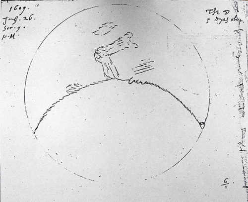
Thomas Harriot’s initial telescopic sketch of the moon from 1609 Source: Wikimedia Commons
Harriot’s map is of course much more detailed than Glibert’s and displays a high level of accuracy. Harriot, however, never published his moon drawings and they remained unknown in the seventeenth century.

Thomas Harriot’s 1613 telescopic map of the moon Source: Wikimedia Commons
The first published drawings of the moon were, of course, those notorius ones of Galileo in the Sidereus Nuncius, which I won’t reproduce here. They can’t really be called maps of the moon as they bear little or no relation to the real moon and might best be described as studies of hypothetical lunar features.
Christoph Scheiner (1575–1650) also produced accurate drawings of the moon in the early phase of telescopic astronomy which he published in his Disquisitiones Mathematicae de Controversiis et Novitatibus Astronomicis in 1614.

Christoph Scheiner moon drawing Source
The Dutch astronomer and cartographer Michel Florent van Langren (1598–1675) published an extensive telescopic map of the moon in 1645.

Michel Florent van Langren Map of the Moon 1645 Source: Wikimedia Commons
This was followed by the even more extensive telescopic map of Johannes Hevelius (1611–1687) in his Selenographia, sive Lunae descriptio in 1647.

Source: Wikimedia Commons

Johannes Hevelius Map of the Moon 1647 Source: Wikimedia Commons
Next up we have the lunar map of Francesco Maia Grimaldi (1618–1663) and Giovanni Battista Riccioli (1598–1671), which supplied the nomenclature for the lunar features that we still use today, and was published in Riccioli’s Almagestum Novum in 1651.


Riccioli/Grimaldi Map of the Moon 1651 Source: Wikimedia Commons
This last is particularly embarrassing for the British Library’s claim that Cassini’s is the first scientific map of the moon, as Cassini was a student of Grimaldi and Riccioli in Bologna and would have been well aware of their selenographical work.
Even if we discount Galileo’s lunar diagrams as not particularly scientific, Cassini comes in, at best, in seventh place in the league table of lunar cartography. I really expect an institution as big and famous as the British Library, with its world-wide impact to put a little more effort into their public presentations of #histSTM.

Reblogged this on Ars, Arte et Labore and commented:
Some beautiful early maps of the Moon – or to give it its proper name, lunar cartography. Educational too, as the author tells us, for anybody who doesn’t already know, that selenography is the science of the physical features of the moon.
Thanks for the post from Aosta, Italy. Please notice some minor typos: Sederius –> Siderius, Bolgna –> Bologna.
Thx!
Thank you for the post. The wiki page on “selenography” says:
The oldest known illustration of the Moon was found in a passage grave in Knowth, County Meath, Ireland. The tomb was carbon dated to 3330–2790 BC.[3] Leonardo da Vinci made and annotated some sketches of the Moon in circa 1500. William Gilbert made a drawing of the Moon in which he denominated a dozen surface features in the late 16th century; it was published posthumously In De Mondo Nostro Sublunari Philosophia Nova. After the invention of the telescope, Thomas Harriot (1609), Galileo Galilei (1609), and Charles Scheiner (1614) made drawings also.[4]
Cassini is mentioned in the references. What defines a “scientific” map?
Whether some of the daubing on the walls the Knowth passage grave represent the moon is a highly speculative and contentious, unsubstantiated theory. Leonardo’s very simple sketches are not in any sense maps of the moon but are illustrations of earth shine i.e. the illumination of the moon by sunlight reflected from the earth. In this case I would say that a ‘scientific’ map is one based on accurate empirical observations.